IMAGES TAKEN NEAR TO
Woodbine Terrace, PEMBROKE, SA71 4PQ
Introduction
This page details the photographs taken nearby to Woodbine Terrace, SA71 4PQ by members of the Geograph project.
The Geograph project started in 2005 with the aim of publishing, organising and preserving representative images for every square kilometre of Great Britain, Ireland and the Isle of Man.

There are currently over 7.5m images from over14,400 individuals and you can help contribute to the project by visiting https://www.geograph.org.uk
Image Map (Loading...)


Getting Data...Please wait
Leaflet Map data © OpenStreetMap
Images are licensed for reuse under creativecommons.org/licenses/by-sa/2.0
Notes
- Clicking on the map will re-center to the selected point.
- The higher the marker number, the further away the image location is from the centre of the postcode.
Image Listing (475 Images Found)
Images are licensed for reuse under creativecommons.org/licenses/by-sa/2.0
Image
Details
Distance
1
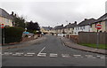
Woodbine Terrace, Pembroke
Looking east from Court Terrace.
Image: © Jaggery
Taken: 12 Sep 2013
0.01 miles
2
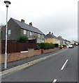
St Ann's Crescent, Pembroke
Viewed from Golden Hill Road.
Image: © Jaggery
Taken: 12 Sep 2013
0.04 miles
3
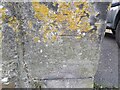
Ordnance Survey Cut Mark
This OS cut mark can be found on the building south side of Riverside. It marks a point 15.480m above mean sea level.
Image: © Adrian Dust
Taken: 22 Mar 2022
0.04 miles
4
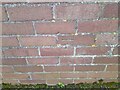
Ordnance Survey Cut Mark
This OS cut mark can be found on the gatepost of Devon House, Woodbine Terrace. It marks a point 13.980m above mean sea level.
Image: © Adrian Dust
Taken: 22 Mar 2022
0.05 miles
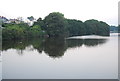

8
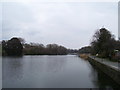
Pembroke Middle Millpond
The Millpond was originally all tidal, but was dammed in the 12th century to build the tidal mill on the bridge. The Railway Embankment was built in the mid 1800s. It split the pond and created the upper millpond, now a nature reserve. In 2003, both the upper and middle Millponds were given Local Nature Reserve (LNR) designation.
Image: © David Dixon
Taken: 10 Sep 2011
0.08 miles