IMAGES TAKEN NEAR TO
Woodbine Terrace, PEMBROKE, SA71 4PG
Introduction
This page details the photographs taken nearby to Woodbine Terrace, SA71 4PG by members of the Geograph project.
The Geograph project started in 2005 with the aim of publishing, organising and preserving representative images for every square kilometre of Great Britain, Ireland and the Isle of Man.

There are currently over 7.5m images from over14,400 individuals and you can help contribute to the project by visiting https://www.geograph.org.uk
Image Map
Images are licensed for reuse under creativecommons.org/licenses/by-sa/2.0
Notes
- Clicking on the map will re-center to the selected point.
- The higher the marker number, the further away the image location is from the centre of the postcode.
Image Listing (515 Images Found)
Images are licensed for reuse under creativecommons.org/licenses/by-sa/2.0
Image
Details
Distance
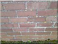
1
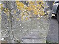
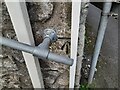
Ordnance Survey Cut Mark
This OS cut mark can be found on the gatepost of Devon House, Woodbine Terrace. It marks a point 13.980m above mean sea level.
Image: © Adrian Dust
Taken: 22 Mar 2022
0.01 miles
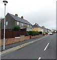
2
St Ann's Crescent, Pembroke
Viewed from Golden Hill Road.
Image: © Jaggery
Taken: 12 Sep 2013
0.03 miles
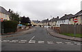
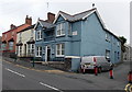
3
Woodbine Terrace, Pembroke
Looking east from Court Terrace.
Image: © Jaggery
Taken: 12 Sep 2013
0.05 miles
4
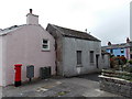
Three boxes and a derelict building opposite Court Terrace, Pembroke
Behind the red post box, grey postman's box (for storing mail during deliveries) and dark green telecoms box is a derelict building. The cross suggests a church, but the name above the door is
The Dimond Press. A notice on the door states that the business has moved to Well Hill Pembroke.
Image: © Jaggery
Taken: 12 Sep 2013
0.06 miles
5
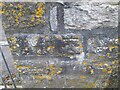
Ordnance Survey Cut Mark
This OS cut mark can be found on No25 Springfield Terrace. It marks a point 50.08ft above mean sea level.
Image: © Adrian Dust
Taken: 22 Mar 2022
0.08 miles
6
Ordnance Survey Cut Mark
This OS cut mark can be found on the gatepost of No1 Paradise Row. It marks a point 10.640m above mean sea level.
Image: © Adrian Dust
Taken: 22 Mar 2022
0.08 miles
7
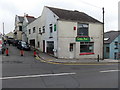
Golden Park, Pembroke
Chinese cuisine takeaway at 4 The Green.
Image: © Jaggery
Taken: 12 Sep 2013
0.08 miles
8
Rock Buildings, Pembroke
Viewed across The Green. A tablet on the blue corner building shows ROCK BUILDINGS 1851.
Image: © Jaggery
Taken: 12 Sep 2013
0.08 miles
10
Ordnance Survey Cut Mark
This OS cut mark can be found on the building south side of Riverside. It marks a point 15.480m above mean sea level.
Image: © Adrian Dust
Taken: 22 Mar 2022
0.08 miles