IMAGES TAKEN NEAR TO
Main Street, PEMBROKE, SA71 4HH
Introduction
This page details the photographs taken nearby to Main Street, SA71 4HH by members of the Geograph project.
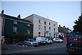
The Geograph project started in 2005 with the aim of publishing, organising and preserving representative images for every square kilometre of Great Britain, Ireland and the Isle of Man.

There are currently over 7.5m images from over14,400 individuals and you can help contribute to the project by visiting https://www.geograph.org.uk
Image Map (Loading...)


Getting Data...Please wait
Leaflet Map data © OpenStreetMap
Images are licensed for reuse under creativecommons.org/licenses/by-sa/2.0
Notes
- Clicking on the map will re-center to the selected point.
- The higher the marker number, the further away the image location is from the centre of the postcode.
Image Listing (444 Images Found)
Images are licensed for reuse under creativecommons.org/licenses/by-sa/2.0
Image
Details
Distance
1
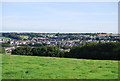
Pembroke
Seen from the Church of St Daniel, to the south.
Image: © N Chadwick
Taken: 28 Aug 2013
0.00 miles
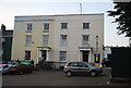
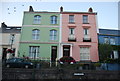
2
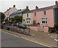
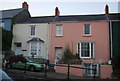
Colourful Main Street houses in Pembroke
Viewed from the corner of East Back.
Image: © Jaggery
Taken: 12 Sep 2013
0.01 miles
3
Tenby House and Oakfield House
Grade II listed. http://www.britishlistedbuildings.co.uk/wa-6407-tenby-house-including-forecourt-and-c19-wa & http://www.britishlistedbuildings.co.uk/wa-84981-oakfield-house-including-forecourt-railin
Image: © N Chadwick
Taken: 26 Aug 2013
0.01 miles
4
Chain Back, Marven House and Orielton House
Grade II listed. http://www.britishlistedbuildings.co.uk/wa-6404-chain-back-with-conduit-and-milestone-pemb & http://www.britishlistedbuildings.co.uk/wa-84978-marven-house-and-forecourt-wall-and-raili & http://www.britishlistedbuildings.co.uk/wa-84984-orielton-house-pembroke
Image: © N Chadwick
Taken: 26 Aug 2013
0.01 miles
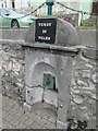
5
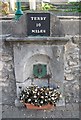
Conduit and milestone
Grade II listed. http://www.britishlistedbuildings.co.uk/wa-6404-chain-back-with-conduit-and-milestone-pemb
Image: © N Chadwick
Taken: 28 Aug 2013
0.01 miles
6
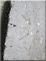
Ordnance Survey Pivot
This OS pivot, a broad arrow with small depression at the point, can be found on the top of the Mile Stone on Main Street. It marks a point 18.230m above mean sea level. http://www.geograph.org.uk/photo/3999605
Image: © Adrian Dust
Taken: 26 May 2014
0.01 miles
7
Mile Stone, Main Street
There is an Ordnance Survey Pivot on the top of this Mile Stone. http://www.geograph.org.uk/photo/3999600
Image: © Adrian Dust
Taken: 26 May 2014
0.01 miles