IMAGES TAKEN NEAR TO
Llewellyn Drive, PEMBROKE, SA71 4EH
Introduction
This page details the photographs taken nearby to Llewellyn Drive, SA71 4EH by members of the Geograph project.
The Geograph project started in 2005 with the aim of publishing, organising and preserving representative images for every square kilometre of Great Britain, Ireland and the Isle of Man.

There are currently over 7.5m images from over14,400 individuals and you can help contribute to the project by visiting https://www.geograph.org.uk
Image Map (Loading...)


Getting Data...Please wait
Leaflet Map data © OpenStreetMap
Images are licensed for reuse under creativecommons.org/licenses/by-sa/2.0
Notes
- Clicking on the map will re-center to the selected point.
- The higher the marker number, the further away the image location is from the centre of the postcode.
Image Listing (47 Images Found)
Images are licensed for reuse under creativecommons.org/licenses/by-sa/2.0
Image
Details
Distance
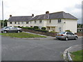
1

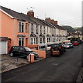
Merchant's Park, Pembroke
A curious bi-level street of terraced houses west of town.
Image: © Peter Whatley
Taken: 22 Jul 2009
0.13 miles
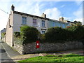
2
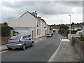
Morgan's Terrace, Pembroke
Morgan's Terrace is a separately-named row of houses in the street named Merchant's Park.
Image: © Jaggery
Taken: 12 Sep 2013
0.13 miles
3

Ordnance Survey Cut Mark
This OS cut mark can be found on the wall between Nos 17 & 19 Mansel Street. It marks a point 12.987m above mean sea level.
Image: © Adrian Dust
Taken: 22 Mar 2022
0.13 miles
4
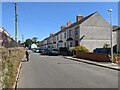
NW end of South Road, Pembroke
Viewed across the street named Merchant's Park.
Image: © Jaggery
Taken: 12 Sep 2013
0.14 miles
8

Ordnance Survey Pivot
This OS pivot can be found on Lake House. It marks a point 10.738m above mean sea level.
Image: © Adrian Dust
Taken: 22 Mar 2022
0.18 miles
9

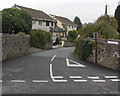
Thomas Street Pembroke
Thomas Street climbs away from Orange Way towards South Road.
Image: © Jaggery
Taken: 12 Sep 2013
0.18 miles
10
Morgans Terrace, Pembroke
Showing position of Postbox No. SA71 56.
See Image] for postbox.
Image: © JThomas
Taken: 16 Oct 2019
0.18 miles