IMAGES TAKEN NEAR TO
Lewis Terrace, PEMBROKE, SA71 4DS
Introduction
This page details the photographs taken nearby to Lewis Terrace, SA71 4DS by members of the Geograph project.
The Geograph project started in 2005 with the aim of publishing, organising and preserving representative images for every square kilometre of Great Britain, Ireland and the Isle of Man.

There are currently over 7.5m images from over14,400 individuals and you can help contribute to the project by visiting https://www.geograph.org.uk
Image Map (Loading...)


Getting Data...Please wait
Leaflet Map data © OpenStreetMap
Images are licensed for reuse under creativecommons.org/licenses/by-sa/2.0
Notes
- Clicking on the map will re-center to the selected point.
- The higher the marker number, the further away the image location is from the centre of the postcode.
Image Listing (252 Images Found)
Images are licensed for reuse under creativecommons.org/licenses/by-sa/2.0
Image
Details
Distance

5
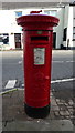
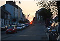
George V postbox on Main Street, Pembroke
Postbox No. SA71 23.
See Image] for context.
Image: © JThomas
Taken: 16 Oct 2019
0.04 miles
6
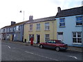
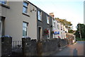
Houses on Main Street, Pembroke
Showing position of Postbox No. SA71 23.
See Image] for postbox.
Image: © JThomas
Taken: 16 Oct 2019
0.04 miles
8
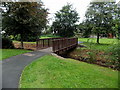
Wooden footbridge over a stream in Pembroke
The footbridge crosses a stream on the north side of Orange Way.
Image: © Jaggery
Taken: 12 Sep 2013
0.05 miles
9
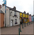
The Hope Inn, Pembroke
Located in East End Square.
Image: © Jaggery
Taken: 12 Sep 2013
0.05 miles
