IMAGES TAKEN NEAR TO
Grove Bridge, PEMBROKE, SA71 4DN
Introduction
This page details the photographs taken nearby to Grove Bridge, SA71 4DN by members of the Geograph project.
The Geograph project started in 2005 with the aim of publishing, organising and preserving representative images for every square kilometre of Great Britain, Ireland and the Isle of Man.

There are currently over 7.5m images from over14,400 individuals and you can help contribute to the project by visiting https://www.geograph.org.uk
Image Map
Images are licensed for reuse under creativecommons.org/licenses/by-sa/2.0
Notes
- Clicking on the map will re-center to the selected point.
- The higher the marker number, the further away the image location is from the centre of the postcode.
Image Listing (197 Images Found)
Images are licensed for reuse under creativecommons.org/licenses/by-sa/2.0
Image
Details
Distance
1
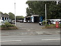
Monddi Design Agency, Orange Way, Pembroke
Image: © Peter Whatley
Taken: 22 Jul 2009
0.00 miles
4
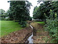
Looking SE along an unnamed stream in Pembroke
Viewed from this http://www.geograph.org.uk/photo/3655735 footbridge on the north side of Orange Way.
Image: © Jaggery
Taken: 12 Sep 2013
0.04 miles
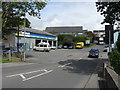
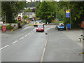
5
Well Hill Garage, Pembroke
Viewed across the A4139.
Image: © Jaggery
Taken: 12 Sep 2013
0.04 miles

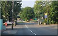
8
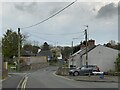
Grove district of Pembroke
At the foot of Grove Hill.
Image: © Alan Hughes
Taken: 23 Apr 2023
0.05 miles
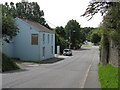
9
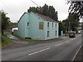
Monddi Design Agency Pembroke
The office is at 3 Well Hill.
Image: © Jaggery
Taken: 12 Sep 2013
0.05 miles
10
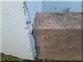
Ordnance Survey Rivet
This OS rivet can be found on the wall of No1 Well Hill. It marks a point 5.760m above mean sea level.
Image: © Adrian Dust
Taken: 22 Mar 2022
0.06 miles