IMAGES TAKEN NEAR TO
Main Street, PEMBROKE, SA71 4DA
Introduction
This page details the photographs taken nearby to Main Street, SA71 4DA by members of the Geograph project.
The Geograph project started in 2005 with the aim of publishing, organising and preserving representative images for every square kilometre of Great Britain, Ireland and the Isle of Man.

There are currently over 7.5m images from over14,400 individuals and you can help contribute to the project by visiting https://www.geograph.org.uk
Image Map (Loading...)


Getting Data...Please wait
Leaflet Map data © OpenStreetMap
Images are licensed for reuse under creativecommons.org/licenses/by-sa/2.0
Notes
- Clicking on the map will re-center to the selected point.
- The higher the marker number, the further away the image location is from the centre of the postcode.
Image Listing (474 Images Found)
Images are licensed for reuse under creativecommons.org/licenses/by-sa/2.0
Image
Details
Distance
1
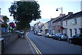
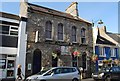
Dragon Alley, Pembroke
Located at 63 Main Street. Their website describes Dragon Alley as
"purveyors of fantastical creatures great and small".
On sale are representations of dragons, fairies, Disney collectables, fantasy figurines etc.
Image: © Jaggery
Taken: 12 Sep 2013
0.00 miles
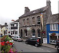
3
HSBC Pembroke
Town centre bank branch at 65 Main Street.
Next door at 67 Main Street is The Cutting Room hair stylists.
Image: © Jaggery
Taken: 12 Sep 2013
0.01 miles
5
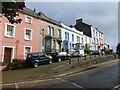
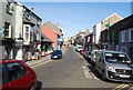
Colourful houses on Main Street, Pembroke
Image: © Ruth Sharville
Taken: 4 Oct 2021
0.01 miles

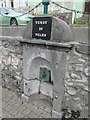
7
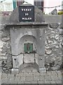
Old Milestone by the A4139, Main Street, Pembroke
By the A4139, in parish of Pembroke (Pembrokeshire District), Main Street, attached to top of drinking fountain.
Inscription reads:-
TENBY
10
MILES
Grade II listed by Cadw. Reference Number: 6404
https://cadwpublic-api.azurewebsites.net/reports/listedbuilding/FullReport?lang=&id=6404
Surveyed
Milestone Society National ID: PEM_TBPM10.
Image: © Milestone Society
Taken: Unknown
0.01 miles
8
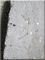
Ordnance Survey Pivot
This OS pivot, a broad arrow with small depression at the point, can be found on the top of the Mile Stone on Main Street. It marks a point 18.230m above mean sea level. http://www.geograph.org.uk/photo/3999605
Image: © Adrian Dust
Taken: 26 May 2014
0.02 miles
9
Mile Stone, Main Street
There is an Ordnance Survey Pivot on the top of this Mile Stone. http://www.geograph.org.uk/photo/3999600
Image: © Adrian Dust
Taken: 26 May 2014
0.02 miles