IMAGES TAKEN NEAR TO
Cedar Court, SWANSEA, SA7 0NG
Introduction
This page details the photographs taken nearby to Cedar Court, SA7 0NG by members of the Geograph project.
The Geograph project started in 2005 with the aim of publishing, organising and preserving representative images for every square kilometre of Great Britain, Ireland and the Isle of Man.

There are currently over 7.5m images from over14,400 individuals and you can help contribute to the project by visiting https://www.geograph.org.uk
Image Map
Images are licensed for reuse under creativecommons.org/licenses/by-sa/2.0
Notes
- Clicking on the map will re-center to the selected point.
- The higher the marker number, the further away the image location is from the centre of the postcode.
Image Listing (6 Images Found)
Images are licensed for reuse under creativecommons.org/licenses/by-sa/2.0
Image
Details
Distance
1
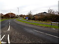
Ffordd Tregof, Swansea
The dark blue sign on the right shows Swansea Vale Resource Centre.
Image: © Jaggery
Taken: 28 Nov 2013
0.14 miles
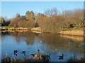
2
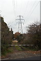
View from Walters Road towards an electricity pylon, Swansea
From the semi-rural part of Walters Road.
Image: © Jaggery
Taken: 28 Nov 2013
0.18 miles
3
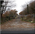
Access road to the railway near Felin Fran bridge, Swansea
Viewed from the western side of this http://www.geograph.org.uk/photo/3804860 bridge. A sturdy black metal barrier and metal gates and fences prevent unauthorised railway access.
Image: © Jaggery
Taken: 28 Nov 2013
0.21 miles
4
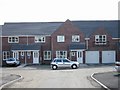
Clos Cadno, Tregof Village, Swansea
This is a cul de sac on a new development nearing completion.
Image: © Roy Douglas
Taken: Unknown
0.22 miles
6
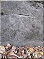
Ordnance Survey Cut Mark
This OS cut mark can be found on the SE buttress of the railway bridge. It marks a point 14.265m above mean sea level.
Image: © Adrian Dust
Taken: 2 Sep 2015
0.25 miles