IMAGES TAKEN NEAR TO
Clos Cadno, SWANSEA, SA7 0ND
Introduction
This page details the photographs taken nearby to Clos Cadno, SA7 0ND by members of the Geograph project.
The Geograph project started in 2005 with the aim of publishing, organising and preserving representative images for every square kilometre of Great Britain, Ireland and the Isle of Man.

There are currently over 7.5m images from over14,400 individuals and you can help contribute to the project by visiting https://www.geograph.org.uk
Image Map
Images are licensed for reuse under creativecommons.org/licenses/by-sa/2.0
Notes
- Clicking on the map will re-center to the selected point.
- The higher the marker number, the further away the image location is from the centre of the postcode.
Image Listing (13 Images Found)
Images are licensed for reuse under creativecommons.org/licenses/by-sa/2.0
Image
Details
Distance
1
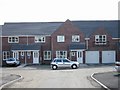
Clos Cadno, Tregof Village, Swansea
This is a cul de sac on a new development nearing completion.
Image: © Roy Douglas
Taken: Unknown
0.04 miles
2
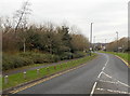
Blawd Road, Swansea
The B4625 Blawd Road heads away from Walters Road into Swansea Vale.
Small wooden posts line one side of the road.
Image: © Jaggery
Taken: 28 Nov 2013
0.06 miles
3
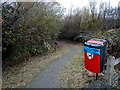
Path near crossroads in Llansamlet, Swansea
The path heads away from Walters Road near a roundabout at crossroads.
Image: © Jaggery
Taken: 28 Nov 2013
0.13 miles
4
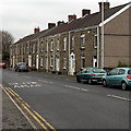
Row of houses, Walters Road, Swansea
Beyond the 45 metre long row of houses, the surroundings change from suburban to semi-rural.
Image: © Jaggery
Taken: 28 Nov 2013
0.14 miles
5
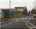
Zebra crossing, Walters Road, Llansamlet, Swansea
Zebra crossings used to be a very common feature in the UK. Many crossings now have pedestrian-controlled traffic lights to stop traffic. This zebra crossing survivor is across Walters Road.
The crossing is marked by Belisha beacons, flashing amber globes on black and white posts on each side of the road, named after Leslie Hore-Belisha the Minister of Transport who introduced them in 1934.
Image: © Jaggery
Taken: 28 Nov 2013
0.16 miles
6
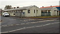
Walters Road business units, Llansamlet, Swansea
On the corner of Walters Road and the B4625.
Image: © Jaggery
Taken: 28 Nov 2013
0.17 miles
7
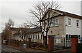
Ysgol Gynradd Gymraeg L?n Las, Llansamlet. Swansea
Welsh-language primary school in Walters Road.
Image: © Jaggery
Taken: 28 Nov 2013
0.19 miles
9
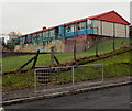
Nursery building, Ysgol Gynradd Gymraeg L?n Las, Llansamlet. Swansea
The colourful building is on the NE side of the school http://www.geograph.org.uk/photo/3804703 in Walters Road.
About 40 children of pre-school age attend the nursery.
Image: © Jaggery
Taken: 28 Nov 2013
0.19 miles
10
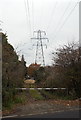
View from Walters Road towards an electricity pylon, Swansea
From the semi-rural part of Walters Road.
Image: © Jaggery
Taken: 28 Nov 2013
0.20 miles