IMAGES TAKEN NEAR TO
Ger Y Nant, SWANSEA, SA7 0HD
Introduction
This page details the photographs taken nearby to Ger Y Nant, SA7 0HD by members of the Geograph project.
The Geograph project started in 2005 with the aim of publishing, organising and preserving representative images for every square kilometre of Great Britain, Ireland and the Isle of Man.

There are currently over 7.5m images from over14,400 individuals and you can help contribute to the project by visiting https://www.geograph.org.uk
Image Map
Images are licensed for reuse under creativecommons.org/licenses/by-sa/2.0
Notes
- Clicking on the map will re-center to the selected point.
- The higher the marker number, the further away the image location is from the centre of the postcode.
Image Listing (3 Images Found)
Images are licensed for reuse under creativecommons.org/licenses/by-sa/2.0
Image
Details
Distance
1
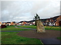
Parc Bryn Heulog
Nodwedd turluniol yn ystad Parc Bryn Heulog.
Landscape feature at Parc Bryn Heulog (trans, sunny hill park) estate.
Image: © Alan Richards
Taken: 1 Mar 2017
0.10 miles
2
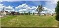
Herbert Thomas Way
Part of the Parc Brynheulog housing development at Birchgrove, Swansea.
Image: © Alan Hughes
Taken: 10 Jun 2019
0.14 miles
3
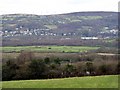
Flood plain of the River Tawe
View of the valley floor south of Glais.
Image: © David Lewis
Taken: 25 Dec 2005
0.17 miles