IMAGES TAKEN NEAR TO
Sandringham Park, SWANSEA, SA7 0ET
Introduction
This page details the photographs taken nearby to Sandringham Park, SA7 0ET by members of the Geograph project.
The Geograph project started in 2005 with the aim of publishing, organising and preserving representative images for every square kilometre of Great Britain, Ireland and the Isle of Man.

There are currently over 7.5m images from over14,400 individuals and you can help contribute to the project by visiting https://www.geograph.org.uk
Image Map
Images are licensed for reuse under creativecommons.org/licenses/by-sa/2.0
Notes
- Clicking on the map will re-center to the selected point.
- The higher the marker number, the further away the image location is from the centre of the postcode.
Image Listing (4 Images Found)
Images are licensed for reuse under creativecommons.org/licenses/by-sa/2.0
Image
Details
Distance
2
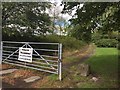
Track and gate
Track leading through gate to Llantarnam Business Park.
Image: © Alan Hughes
Taken: 10 Aug 2018
0.11 miles
3
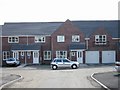
Clos Cadno, Tregof Village, Swansea
This is a cul de sac on a new development nearing completion.
Image: © Roy Douglas
Taken: Unknown
0.17 miles
4
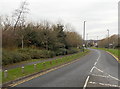
Blawd Road, Swansea
The B4625 Blawd Road heads away from Walters Road into Swansea Vale.
Small wooden posts line one side of the road.
Image: © Jaggery
Taken: 28 Nov 2013
0.19 miles