IMAGES TAKEN NEAR TO
New Hedges, TENBY, SA70 8TN
Introduction
This page details the photographs taken nearby to SA70 8TN by members of the Geograph project.
The Geograph project started in 2005 with the aim of publishing, organising and preserving representative images for every square kilometre of Great Britain, Ireland and the Isle of Man.

There are currently over 7.5m images from over14,400 individuals and you can help contribute to the project by visiting https://www.geograph.org.uk
Image Map
Images are licensed for reuse under creativecommons.org/licenses/by-sa/2.0
Notes
- Clicking on the map will re-center to the selected point.
- The higher the marker number, the further away the image location is from the centre of the postcode.
Image Listing (65 Images Found)
Images are licensed for reuse under creativecommons.org/licenses/by-sa/2.0
Image
Details
Distance
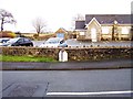
1

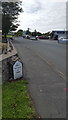
Parking area and pillarbox outside McColl's Mini Market and Post Office, New Hedges
http://www.geograph.org.uk/photo/5225446 to a view of the mini market in the small village of New Hedges, Pembrokeshire.
Image: © Jaggery
Taken: 16 Jul 2016
0.00 miles
2
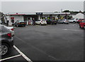
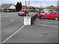
McColl's Mini Market and Post Office, New Hedges
In July 2016, a post office is inside McColls, which is set back from the west side of the B4316 in the small village of New Hedges, Pembrokeshire. A cash dispensing machine is in the wall on the left.
Image: © Jaggery
Taken: 16 Jul 2016
0.00 miles
3
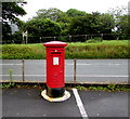
Queen Elizabeth II pillarbox, New Hedges, Pembrokeshire
On the right here, http://www.geograph.org.uk/photo/5225531 facing McColl's Mini Market and Post Office.
Image: © Jaggery
Taken: 16 Jul 2016
0.01 miles
4
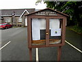
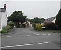
St Mary Out Liberty Community Council noticeboard, New Hedges, Pembrokeshire
The noticeboard is on the B4316 side of New Hedges Village Hall. http://www.geograph.org.uk/photo/5225421
The Pembrokeshire County Council website states that St Mary Out Liberty is a community in the southeast of Pembrokeshire, between Saundersfoot to the north and Tenby to the south. The name St Mary Out Liberty refers to the fact that this part of the parish was (and is) outside the borough of Tenby. The name dates from 1834.
Image: © Jaggery
Taken: 16 Jul 2016
0.01 miles
5
Mile marker
An old mile marker by the roadside in New Hedges.
Image: © Peter Mackenzie
Taken: 20 Aug 2020
0.02 miles
6
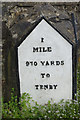
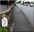
Milepost in New Hedges
The A478 now by-passes New Hedges but this milepost is still here outside the village hall giving a very precise distance to Tenby of 1 mile 910 yards. It is easily walkable but there are regular buses from here as well. For the context see Image
Image: © Stephen McKay
Taken: 10 Apr 2018
0.02 miles
8
St Anne's Drive, New Hedges, Pembrokeshire
Viewed across the B4316. The Lake Drive junction is ahead on the left, 25 metres from the B4316.
Image: © Jaggery
Taken: 16 Jul 2016
0.02 miles
9
Yardage on a New Hedges milestone, Pembrokeshire
Alongside the B4316 in the small village of New Hedges, showing 1 mile 970 yards to Tenby.
I wondered what was the point of such precision, especially as there is no indication of where in Tenby is this exact distance ahead. The opposite side shows 9 miles to Narberth - no yardage on that side!
Image: © Jaggery
Taken: 16 Jul 2016
0.02 miles