IMAGES TAKEN NEAR TO
Redberth, TENBY, SA70 8RR
Introduction
This page details the photographs taken nearby to SA70 8RR by members of the Geograph project.
The Geograph project started in 2005 with the aim of publishing, organising and preserving representative images for every square kilometre of Great Britain, Ireland and the Isle of Man.

There are currently over 7.5m images from over14,400 individuals and you can help contribute to the project by visiting https://www.geograph.org.uk
Image Map
Images are licensed for reuse under creativecommons.org/licenses/by-sa/2.0
Notes
- Clicking on the map will re-center to the selected point.
- The higher the marker number, the further away the image location is from the centre of the postcode.
Image Listing (6 Images Found)
Images are licensed for reuse under creativecommons.org/licenses/by-sa/2.0
Image
Details
Distance

2
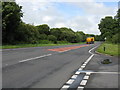
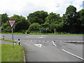
A477 At Junction For East Williamston
Image: © Peter Whatley
Taken: 21 Jul 2009
0.09 miles

4
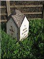
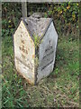
Old Milestone by the A477, north east of Redberth
Pembroke double plate by the A477, in parish of Carew (Pembrokeshire District), Redberth, NW of village. Re-located during road improvements.
Inscription reads:- : 25 / MILES / TO / CARMARTHEN : : 3 / MILES / 512 YARDS / TO / PEMBROKE :
Precise but inaccurate. It is believed that either the milestones or the plates have been misplaced. See also: Image for a suggestion.
Surveyed
Milestone Society National ID: PEM_CMHP25.
Image: © Milestone Society
Taken: Unknown
0.20 miles