IMAGES TAKEN NEAR TO
Lady Park, TENBY, SA70 8JH
Introduction
This page details the photographs taken nearby to Lady Park, SA70 8JH by members of the Geograph project.
The Geograph project started in 2005 with the aim of publishing, organising and preserving representative images for every square kilometre of Great Britain, Ireland and the Isle of Man.

There are currently over 7.5m images from over14,400 individuals and you can help contribute to the project by visiting https://www.geograph.org.uk
Image Map
Images are licensed for reuse under creativecommons.org/licenses/by-sa/2.0
Notes
- Clicking on the map will re-center to the selected point.
- The higher the marker number, the further away the image location is from the centre of the postcode.
Image Listing (48 Images Found)
Images are licensed for reuse under creativecommons.org/licenses/by-sa/2.0
Image
Details
Distance
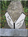
1
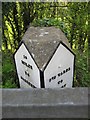
Old Milestone by the A478, Narberth Road, Lady Park, Tenby
Pembroke double plate by the A478, Narberth Road, in parish of Tenby (Pembrokeshire District), opposite Lady Park, behind barrier.
Inscription reads:-
: 10 / MILES / TO / NARBERTH : : 970 YARDS / TO / TENBY :
Surveyed
Milestone Society National ID: PEM_TBNB00
Image: © Milestone Society
Taken: Unknown
0.06 miles
2
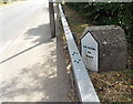
Yardstone in Tenby
Located alongside the A478 Narberth Road near a Tenby boundary sign. I wondered exactly where this distance marker was 970 yards from. The other side http://www.geograph.org.uk/photo/4027291 shows 10 miles to Narberth.
Image: © Jaggery
Taken: 13 Jul 2013
0.06 miles
3
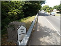
Narberth Road milestone, Tenby
Located alongside the A478 in Tenby 10 miles from Narberth.
The other side http://www.geograph.org.uk/photo/4027301 shows 970 yards to Tenby.
Image: © Jaggery
Taken: 13 Jul 2013
0.06 miles
5
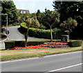
Welcome to Tenby
The Welcome sign is at the northern edge of Tenby,
at the junction of the A478 Narberth Road and Lady Park (on the left).
Image: © Jaggery
Taken: 13 Jul 2013
0.07 miles
6
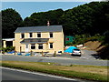
House at the northern edge of Tenby
Near the corner of Narberth Road and Lady Park, a few metres from this http://www.geograph.org.uk/photo/4027321 Welcome to Tenby sign.
Image: © Jaggery
Taken: 13 Jul 2013
0.09 miles
7
Upper Hill Park, Tenby
A nearby street name sign shows UPPER HILL PARK LEADING TO LADY PARK AND SEASCAPE.
Image: © Jaggery
Taken: 13 Jul 2013
0.09 miles
8
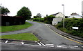
Upper Hill Park, Tenby
Viewed from the A478 Narberth Road, this is the southern end of the road named Upper Hill Park.
A nearby street name sign shows that Upper Hill Park leads to Lady Park and Seascape.
Image: © Jaggery
Taken: 16 Jul 2016
0.10 miles
9
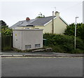
Greenfields Park electricity substation, Tenby
Located on the right here, http://www.geograph.org.uk/photo/5487465 the grey cabinet is a Western Power Distribution electricity substation.
Its identifier is GREENFIELDS PARK TENBY S/S 604502.
Image: © Jaggery
Taken: 16 Jul 2016
0.13 miles
10

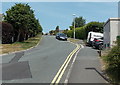
Houses at the western end of Narberth Road, Tenby
I wondered if the lamppost on the pedestrian refuge was recently installed, awaiting a lamp to be fitted.
Image: © Jaggery
Taken: 13 Jul 2013
0.14 miles