IMAGES TAKEN NEAR TO
The Glebe, TENBY, SA70 8HA
Introduction
This page details the photographs taken nearby to The Glebe, SA70 8HA by members of the Geograph project.
The Geograph project started in 2005 with the aim of publishing, organising and preserving representative images for every square kilometre of Great Britain, Ireland and the Isle of Man.

There are currently over 7.5m images from over14,400 individuals and you can help contribute to the project by visiting https://www.geograph.org.uk
Image Map
Images are licensed for reuse under creativecommons.org/licenses/by-sa/2.0
Notes
- Clicking on the map will re-center to the selected point.
- The higher the marker number, the further away the image location is from the centre of the postcode.
Image Listing (283 Images Found)
Images are licensed for reuse under creativecommons.org/licenses/by-sa/2.0
Image
Details
Distance
1
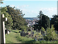
Tomb with a View
Local cemetery on a hillside overlooking the picturesque town of Tenby.
Image: © Dennis Turner
Taken: 16 Sep 2005
0.08 miles
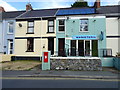
2
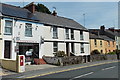
Washeteria, Tenby
Launderette in Broadwell Hayes.
Image: © Jaggery
Taken: 13 Jul 2013
0.08 miles
3
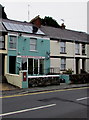
Washeteria, Tenby
Broadwell Hayes launderette.
Image: © Jaggery
Taken: 16 Jul 2016
0.08 miles
4
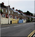
Stepped row of houses, Broadwell Hayes, Tenby
The A4218 Broadwell Hayes descends towards Tenby town centre.
Image: © Jaggery
Taken: 16 Jul 2016
0.08 miles
5
Washeteria on Heywood Lane, Tenby
Showing position of Postbox No. SA70 11.
See Image] for postbox.
Image: © JThomas
Taken: 16 Oct 2019
0.08 miles
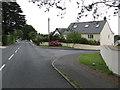
6
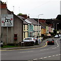
A4139 directions sign, Tenby
At the junction of the A4128 Broadwell Hayes and the B4318 Heywood Lane.
Image: © Jaggery
Taken: 16 Jul 2016
0.08 miles
7
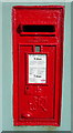
George VI postbox on Heywood Lane, Tenby
Postbox No. SA70 11.
See Image] for context.
Image: © JThomas
Taken: 16 Oct 2019
0.08 miles
8
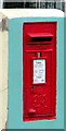
King George VI postbox outside Washeteria, Tenby
Located here. http://www.geograph.org.uk/photo/5181745
Image: © Jaggery
Taken: 16 Jul 2016
0.08 miles
10
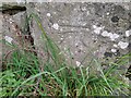
Ordnance Survey Cut Mark
This OS cut mark can be found on the wall at Cogmill Cottage. It marks a point 8.759m above mean sea level.
Image: © Adrian Dust
Taken: 18 Mar 2022
0.08 miles