IMAGES TAKEN NEAR TO
Wheelers Way, TENBY, SA70 7TU
Introduction
This page details the photographs taken nearby to Wheelers Way, SA70 7TU by members of the Geograph project.
The Geograph project started in 2005 with the aim of publishing, organising and preserving representative images for every square kilometre of Great Britain, Ireland and the Isle of Man.

There are currently over 7.5m images from over14,400 individuals and you can help contribute to the project by visiting https://www.geograph.org.uk
Image Map
Images are licensed for reuse under creativecommons.org/licenses/by-sa/2.0
Notes
- Clicking on the map will re-center to the selected point.
- The higher the marker number, the further away the image location is from the centre of the postcode.
Image Listing (7 Images Found)
Images are licensed for reuse under creativecommons.org/licenses/by-sa/2.0
Image
Details
Distance
1
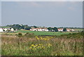
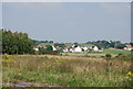
Baldwin's Moor
Houses adjacent to RAR Manorbier.
Image: © Dennis Turner
Taken: 18 Sep 2005
0.03 miles
2
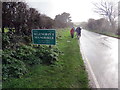
Gadael Maenorbyr / Exiting Manorbier
Cerddwyr yn gadael pentre Maenorbyr yn ystod cawad trwm.
Walkers exiting Manorbier < Maenorbyr (translate. Pyr's estate) during a heavy shower.
Image: © Alan Richards
Taken: 12 Jan 2020
0.11 miles
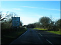
3
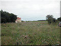
Within range of the Range
View near to Manorbier military camp artillery firing range.
Image: © Dennis Turner
Taken: 18 Sep 2005
0.17 miles
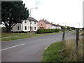
6
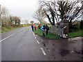
Cerddwyr ar y A4139 / Walkers on the A4139
Cerddwyr yn dilyn yr A4139 ger anhedd-dy o'r enw Baldwin's Moor.
Walkers following the A4139 near a property known as Baldwin's Moor.
Image: © Alan Richards
Taken: 12 Jan 2020
0.22 miles