IMAGES TAKEN NEAR TO
Marsh Road, TENBY, SA70 7RA
Introduction
This page details the photographs taken nearby to Marsh Road, SA70 7RA by members of the Geograph project.
The Geograph project started in 2005 with the aim of publishing, organising and preserving representative images for every square kilometre of Great Britain, Ireland and the Isle of Man.

There are currently over 7.5m images from over14,400 individuals and you can help contribute to the project by visiting https://www.geograph.org.uk
Image Map
Images are licensed for reuse under creativecommons.org/licenses/by-sa/2.0
Notes
- Clicking on the map will re-center to the selected point.
- The higher the marker number, the further away the image location is from the centre of the postcode.
Image Listing (11 Images Found)
Images are licensed for reuse under creativecommons.org/licenses/by-sa/2.0
Image
Details
Distance
1
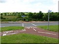
Junction in a junction
A cycle path junction inside the triangle of the road junction. A confusing and possibly dangerous junction - the flowers in the background suggest a recent road accident.
Image: © Colin Bell
Taken: 16 Jun 2008
0.01 miles
3
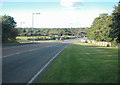
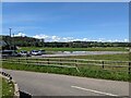
Penally bypass
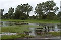
Northern end of Penally bypass. On the 1940s OS map the area in view is known as Hoyles Mouth, though on OS Get-a-Map the area is known as Holloway Bridge. The main road crosses a brook or small river which runs through the marshes to the west of the road.
Image: © Dennis Turner
Taken: 17 Sep 2005
0.05 miles
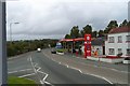
5
The car park at the sports ground
Near Penally.
Image: © David Medcalf
Taken: 16 Aug 2023
0.12 miles
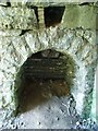
6
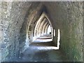
Lime kiln, Kiln Park
Looking along the inside of a bank of limekilns, which originally had a railway track through so that the lime could be loaded directly into the railway wagons.
Image: © David Luther Thomas
Taken: 28 May 2007
0.17 miles
8
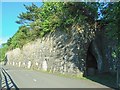
Lime kiln
External view (and from the opposite end) of Image
Image: © David Luther Thomas
Taken: 28 May 2007
0.20 miles
9
Lime kiln detail
One of the "pots".
Image: © David Luther Thomas
Taken: 28 May 2007
0.20 miles