IMAGES TAKEN NEAR TO
Penally Heights, TENBY, SA70 7QP
Introduction
This page details the photographs taken nearby to Penally Heights, SA70 7QP by members of the Geograph project.
The Geograph project started in 2005 with the aim of publishing, organising and preserving representative images for every square kilometre of Great Britain, Ireland and the Isle of Man.

There are currently over 7.5m images from over14,400 individuals and you can help contribute to the project by visiting https://www.geograph.org.uk
Image Map
Images are licensed for reuse under creativecommons.org/licenses/by-sa/2.0
Notes
- Clicking on the map will re-center to the selected point.
- The higher the marker number, the further away the image location is from the centre of the postcode.
Image Listing (26 Images Found)
Images are licensed for reuse under creativecommons.org/licenses/by-sa/2.0
Image
Details
Distance
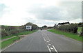
1
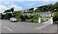
Penally Heights, Penally
Houses on rising ground north of a side road above the A4139.
Image: © Jaggery
Taken: 15 Jun 2016
0.04 miles
2
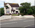
Brambles Lodge B&B, Penally
Guest house in Penally Heights, 75 metres north of the A4139.
Image: © Jaggery
Taken: 15 Jun 2016
0.05 miles
3
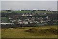
Houses in Penally
Taken from the Pembrokeshire Coast Path.
Image: © Ian S
Taken: 22 Jan 2015
0.05 miles
4
This way to Penally Heights
Viewed across the A4139 at the edge of Penally, a village near Tenby in coastal south Pembrokeshire.
Image: © Jaggery
Taken: 15 Jun 2016
0.06 miles
5
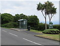
Bus stop and shelter, Penally
Located a few metres from the Croeso/Welcome sign. http://www.geograph.org.uk/photo/4998328
Image: © Jaggery
Taken: 15 Jun 2016
0.07 miles
6
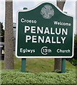
Bilingual Croeso/Welcome Penalun/Penally sign
The Welsh/English sign is at the edge of a side road, http://www.geograph.org.uk/photo/4998365 facing the A4139 junction.
Image: © Jaggery
Taken: 15 Jun 2016
0.07 miles
7
Warning sign and bilingual text, Penally
Showing No footway for ¾ mile and the Welsh language equivalent.
Image: © Jaggery
Taken: 15 Jun 2016
0.08 miles
8
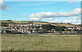
Penally Village
The houses shown in this view taken from the Pembrokeshire Coastal path appear to have been built since the 1940s edition of the OS map.
Image: © Dennis Turner
Taken: 17 Sep 2005
0.08 miles
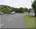
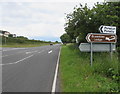
9
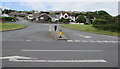
A4139 junction with Penally Heights
The A4139 is effectively the Penally by-pass at this point.
Image: © Stuart Logan
Taken: 7 Oct 2011
0.09 miles
10
Turn left here for Penalun/Penally and Brambles Lodge B&B
On the south side of the A4139, opposite this http://www.geograph.org.uk/photo/4998369 junction.
Penalun is the Welsh name of the village known as Penally in English.
Brambles Lodge B&B http://www.geograph.org.uk/photo/4998276 is about 80 metres from the sign.
Image: © Jaggery
Taken: 15 Jun 2016
0.09 miles