IMAGES TAKEN NEAR TO
Strawberry Lane, TENBY, SA70 7QA
Introduction
This page details the photographs taken nearby to Strawberry Lane, SA70 7QA by members of the Geograph project.
The Geograph project started in 2005 with the aim of publishing, organising and preserving representative images for every square kilometre of Great Britain, Ireland and the Isle of Man.

There are currently over 7.5m images from over14,400 individuals and you can help contribute to the project by visiting https://www.geograph.org.uk
Image Map
Images are licensed for reuse under creativecommons.org/licenses/by-sa/2.0
Notes
- Clicking on the map will re-center to the selected point.
- The higher the marker number, the further away the image location is from the centre of the postcode.
Image Listing (79 Images Found)
Images are licensed for reuse under creativecommons.org/licenses/by-sa/2.0
Image
Details
Distance
2
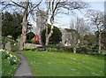
The path to the church, Penally
The path is across the upper end of the village green.
Image: © Humphrey Bolton
Taken: 30 Mar 2011
0.12 miles
3
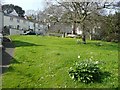
The village green, Penally
Small and steeply sloping, but attractive.
Image: © Humphrey Bolton
Taken: 30 Mar 2011
0.12 miles
4
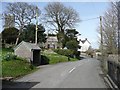
The village street, Penally
This was the main road before the bypass was constructed.
Image: © Humphrey Bolton
Taken: 30 Mar 2011
0.12 miles
5
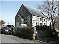
Former Congregational Chapel, Penally
Image: © Humphrey Bolton
Taken: 30 Mar 2011
0.14 miles
6
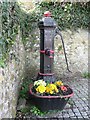
Jubilee water pump, Penally
Commemorating Queen Victoria's Golden Jubilee, 1887.
Image: © Humphrey Bolton
Taken: 30 Mar 2011
0.14 miles
7
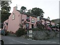
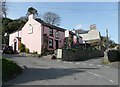
The Cross Inn, Penally
The Cross Inn is one of a number of pubs found in Penally. As well as good food and drink, the proprietors have provided a pleasant environment both inside and out to enjoy a relaxing evening with friends. The Inn commands spectacular views across Caldey Sound and there are many footpaths and walks to enjoy in and around this remarkably picturesque village. Well worth making this location a destination if not a stop on a journey through Pembrokshire.
Image: © Hywel Williams
Taken: 11 Sep 2007
0.14 miles
9
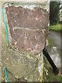
Ordnance Survey Cut Mark
This OS cut mark can be found on the NW angle of St Nicholas Church. It marks a point 19.122m above mean sea level.
Image: © Adrian Dust
Taken: 14 Nov 2015
0.16 miles
10
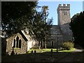
Church of St Nicholas and St Teilo
Taken on a tranquil evening with the sun lying low on the horizon, this looks like a really peaceful scene. There is much evidence of early Celtic Christian activity here - there is a 6th century Celtic cross inside the church, known as the Wheelhead Cross and even the circular shape of the churchyard reveal its Celtic origins.
It is believed that St Teilo (from whom the church takes its name) was born in the locality and it is believed that he became the first bishop of Llandaff and was a contemporary of St David.
Image: © Hywel Williams
Taken: 29 Jul 2007
0.16 miles