IMAGES TAKEN NEAR TO
Penally, TENBY, SA70 7PJ
Introduction
This page details the photographs taken nearby to SA70 7PJ by members of the Geograph project.
The Geograph project started in 2005 with the aim of publishing, organising and preserving representative images for every square kilometre of Great Britain, Ireland and the Isle of Man.

There are currently over 7.5m images from over14,400 individuals and you can help contribute to the project by visiting https://www.geograph.org.uk
Image Map
Images are licensed for reuse under creativecommons.org/licenses/by-sa/2.0
Notes
- Clicking on the map will re-center to the selected point.
- The higher the marker number, the further away the image location is from the centre of the postcode.
Image Listing (15 Images Found)
Images are licensed for reuse under creativecommons.org/licenses/by-sa/2.0
Image
Details
Distance
1
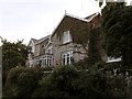
Penally Abbey Country House Hotel and Restaurant
With its lovely setting and beautiful view over the sea, the Penally House Country Hotel and Restaurant is a gothic style country house built adjacent to the remains of a 12th century Norman church. The hotel itself comprises not only this building but has other buildings that used to be part of the country estate, St Deiniol's Lodge and The Coach House, and the restaurant is well known locally for its fine cuisine.
There are far better pictures than mine on their web site: http://www.penally-abbey.com/
Image: © Hywel Williams
Taken: 11 Sep 2007
0.14 miles
2
12th Century Norman Church
Situated on the grounds of Penally Abbey Country House & Restaurant are the historic ruins of a 12th Century Church. I believe that this could well have been part of a larger monastic structure that occupied the land then.
Image: © Hywel Williams
Taken: 11 Sep 2007
0.15 miles
3
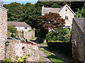
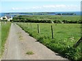
The Ritec Walk
Lane ascends from Penally to The Ridgeway
Image: © John Duckfield
Taken: 12 Sep 2010
0.15 miles
4
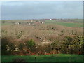
Gumfreston from Frankleston
The view is across the Ritec River valley towards Gumfreston taken from the slopes of the Ridgeway an ancient road between Tenby and Pembroke.
Image: © Angela Jones
Taken: 24 Dec 2001
0.15 miles

6
View of Caldey Island from Strawberry Lane
Looking down Strawberry Lane as it descends into Penally. Giltar Point is the end of the headland, with a clear view of Caldey Island and the smaller St. Margaret's Island to the right.
Image: © David Luther Thomas
Taken: 29 May 2007
0.15 miles
7
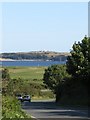
Caldey Island, as seen from the A4139
As the A4139 sweeps past the village of Penally, a stunning view can be seen looking over Caldey Sound to Caldey Island, where Caldey Island lighthouse can be seen standing prominently on the island's highest hill. This view can also be enjoyed from many locations in and around Penally.
Image: © Hywel Williams
Taken: 29 Jul 2007
0.16 miles
8
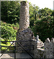
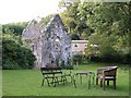
Corn Mwg
Chimney piece at Abbey Hotel.
Image: © John Duckfield
Taken: 12 Sep 2010
0.17 miles
9

Rose
Taken near the Penally Abbey Country House Hotel and Restaurant, I believe this image sums up the tranquil nature of the floral village of Penally. In the distance in the soft focus, Caldey Island can be seen over Caldey Sound.
Image: © Hywel Williams
Taken: 11 Sep 2007
0.18 miles
10
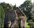
Penally Abbey
Ruins in Penally Abbey Hotel.
Image: © John Duckfield
Taken: 12 Sep 2010
0.19 miles