IMAGES TAKEN NEAR TO
Broadfield Hill, SAUNDERSFOOT, SA69 9PA
Introduction
This page details the photographs taken nearby to Broadfield Hill, SA69 9PA by members of the Geograph project.
The Geograph project started in 2005 with the aim of publishing, organising and preserving representative images for every square kilometre of Great Britain, Ireland and the Isle of Man.

There are currently over 7.5m images from over14,400 individuals and you can help contribute to the project by visiting https://www.geograph.org.uk
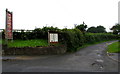
Image Map (Loading...)


Getting Data...Please wait
Leaflet Map data © OpenStreetMap
Images are licensed for reuse under creativecommons.org/licenses/by-sa/2.0
Notes
- Clicking on the map will re-center to the selected point.
- The higher the marker number, the further away the image location is from the centre of the postcode.
Image Listing (22 Images Found)
Images are licensed for reuse under creativecommons.org/licenses/by-sa/2.0
Image
Details
Distance
1
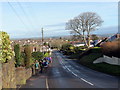
Dilyn yr B4316 / Following the B4316
Cerddwyr yn dilyn yr B4316 i Saundersfoot.
Walkers following the B4316 to Saundersfoot.
Image: © Alan Richards
Taken: 3 Feb 2019
0.02 miles
2
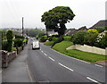
Descent north-northeastwards into Saundersfoot
The B4316 Broadfield Hill descends towards the centre of Saundersfoot in SE Pembrokeshire.
Image: © Jaggery
Taken: 16 Jul 2016
0.03 miles
3
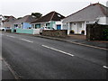
Broadfield Hill bungalows, Saundersfoot
On the west side of the B4316 Broadfield Hill.
Image: © Jaggery
Taken: 16 Jul 2016
0.05 miles
4

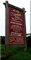
Saundersfoot Bay Leisure Park name sign
In a flower bed on the east side of the B4316 Broadfield Hill. http://www.geograph.org.uk/photo/5210845
Image: © Jaggery
Taken: 16 Jul 2016
0.07 miles
5
Entrance to Saundersfoot Bay Leisure Park
From Broadfield Hill. A notice at the entrance shows Sorry - no tents, tourers or rental accommodation.
Image: © Jaggery
Taken: 16 Jul 2016
0.07 miles
6
Access road to Broadfield Farm Holiday Park, Saundersfoot
From the B4316 Broadfield Hill. http://www.geograph.org.uk/photo/5210859 to the nameboard on the left.
Image: © Jaggery
Taken: 16 Jul 2016
0.08 miles
7
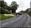
Cycling out of Saundersfoot
Cyclists on the B4316 Broadfield Hill ride south away from Saundersfoot.
Image: © Jaggery
Taken: 16 Jul 2016
0.09 miles
8
Broadfield Farm Holiday Park nameboard, Saundersfoot
Located here. http://www.geograph.org.uk/photo/5210855
Image: © Jaggery
Taken: 16 Jul 2016
0.09 miles
9
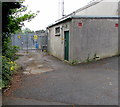
West side of Broadfield electricity substation, Saundersfoot
Looking towards the locked entrance to the Western Power Distribution electricity substation which extends eastwards for 75 metres. The identifier label shows Site Ref No 307 and the names Western Power Distribution and Surf Telecoms Ltd, who operate this site.
Image: © Jaggery
Taken: 16 Jul 2016
0.09 miles
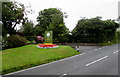
10
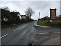
Broadfield Hill
Broadfield Hill passing entrance to Broadfield Farm
Image: © Shaun Ferguson
Taken: 10 Apr 2018
0.13 miles