IMAGES TAKEN NEAR TO
Malin Court, SAUNDERSFOOT, SA69 9NN
Introduction
This page details the photographs taken nearby to Malin Court, SA69 9NN by members of the Geograph project.
The Geograph project started in 2005 with the aim of publishing, organising and preserving representative images for every square kilometre of Great Britain, Ireland and the Isle of Man.

There are currently over 7.5m images from over14,400 individuals and you can help contribute to the project by visiting https://www.geograph.org.uk
Image Map (Loading...)


Getting Data...Please wait
Leaflet Map data © OpenStreetMap
Images are licensed for reuse under creativecommons.org/licenses/by-sa/2.0
Notes
- Clicking on the map will re-center to the selected point.
- The higher the marker number, the further away the image location is from the centre of the postcode.
Image Listing (311 Images Found)
Images are licensed for reuse under creativecommons.org/licenses/by-sa/2.0
Image
Details
Distance
1
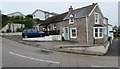
St Brides Cottage, St Brides Hill, Saundersfoot
Holiday rental cottage alongside a bend in the B4316 St Brides Hill.
Image: © Jaggery
Taken: 16 Jul 2016
0.01 miles
2
White Sails, Saundersfoot
Holiday home above the B4316 with views over Saundersfoot Harbour, Saundersfoot Bay and Carmarthen Bay.
Image: © Jaggery
Taken: 16 Jul 2016
0.02 miles
3

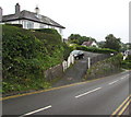
Elbow bend in the B4316, Saundersfoot
Part of the steep, bendy route from Saundersfoot towards Tenby, the B4316 bends through 90 degrees ahead.
Image: © Jaggery
Taken: 16 Jul 2016
0.02 miles
4
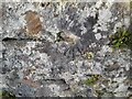
Ordnance Survey Cut Mark
This damaged OS cut mark can be found on the wall south side of the road. It marks a point 23.534m above mean sea level.
Image: © Adrian Dust
Taken: 7 Apr 2022
0.02 miles
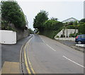
5
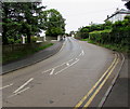
No parking on the B4316 in Saundersfoot
Between Stammers Road (behind the camera) and St Bride's Lane,
double yellow lines on both sides of the B4316 indicate no parking at any time
Image: © Jaggery
Taken: 16 Jul 2016
0.03 miles
6
Beacon on high ground above Saundersfoot Bay
Set back from this http://www.geograph.org.uk/photo/5041053 bend in the B4316 about 25 metres (c80 feet) above sea level.
Image: © Jaggery
Taken: 16 Jul 2016
0.03 miles
7
No parking on the B4316 St Brides Hill, Saundersfoot
Double yellow lines on both sides of the road indicate no parking at any time.
Image: © Jaggery
Taken: 16 Jul 2016
0.04 miles
8
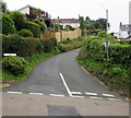
St Bride's Lane, Saundersfoot
Ascending from the B4316.
Image: © Jaggery
Taken: 16 Jul 2016
0.04 miles
9
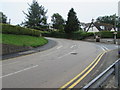
Bend in the B4316, Saundersfoot
This part of the B4316 from Saundersfoot towards Tenby is steep and bendy.
Ahead, past the Stammers Road junction, the B4316 bends through nearly 90 degrees.
A sign http://www.geograph.org.uk/photo/5040242 behind the camera shows a 12% gradient.
Image: © Jaggery
Taken: 16 Jul 2016
0.04 miles
10
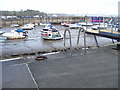
Saundersfoot Harbour - with old mooring ring
Image: © welshbabe
Taken: 30 Oct 2015
0.04 miles