IMAGES TAKEN NEAR TO
Brooklands Close, SAUNDERSFOOT, SA69 9NE
Introduction
This page details the photographs taken nearby to Brooklands Close, SA69 9NE by members of the Geograph project.
The Geograph project started in 2005 with the aim of publishing, organising and preserving representative images for every square kilometre of Great Britain, Ireland and the Isle of Man.

There are currently over 7.5m images from over14,400 individuals and you can help contribute to the project by visiting https://www.geograph.org.uk
Image Map (Loading...)


Getting Data...Please wait
Leaflet Map data © OpenStreetMap
Images are licensed for reuse under creativecommons.org/licenses/by-sa/2.0
Notes
- Clicking on the map will re-center to the selected point.
- The higher the marker number, the further away the image location is from the centre of the postcode.
Image Listing (263 Images Found)
Images are licensed for reuse under creativecommons.org/licenses/by-sa/2.0
Image
Details
Distance
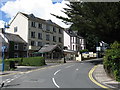
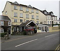
2
Milford Terrace houses, Saundersfoot
The taller building on the right is the Gower Hotel. http://www.geograph.org.uk/photo/5036871
Image: © Jaggery
Taken: 16 Jul 2016
0.03 miles
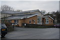
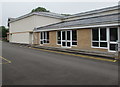
4
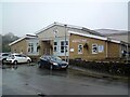
Regency Hall Community Centre, Saundersfoot
The location of Saundersfoot Library and Information Centre, Regency Hall
Community Centre is alongside an unnamed side street south of Milford Street.
Image: © Jaggery
Taken: 16 Jul 2016
0.03 miles
5
The Gower Hotel, Saundersfoot
Located in Milford Terrace.
Image: © Jaggery
Taken: 16 Jul 2016
0.03 miles
6
Saundersfoot Sports and Social Club
On the north side of the bowling green.
The club's football and cricket teams play on the adjacent King George V playing fields.
Image: © Jaggery
Taken: 16 Jul 2016
0.03 miles
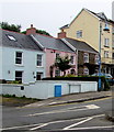
7
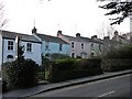
Colourful cottages, Saundersfoot
On the one way system when leaving Saundersfoot to the north.
Image: © Robin Drayton
Taken: 20 Mar 2009
0.04 miles
8
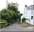
West along Brookland Place, Saundersfoot
Viewed from the corner of Milford Street. The edge of a Milford Terrace house http://www.geograph.org.uk/photo/5036968 is on the right.
Image: © Jaggery
Taken: 16 Jul 2016
0.04 miles
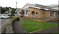
9
Regency Hall, Saundersfoot
Built in 2013 following the demolition of the old hall on the same site, it occupies a central village location alongside a large car park. The Hall is suitable for a variety of uses including conferences, wedding receptions, parties, concerts, dance classes, etc. Access to the bar facilities of the Sports & Social Club is through interconnecting doors at the side of the Main Hall. Saundersfoot Library is also located in the hall. Website: https://regencyhall.org.uk/
Image: © Gerald England
Taken: 18 Oct 2021
0.04 miles
10
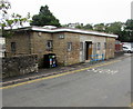
Public toilets south of Milford Street, Saundersfoot
Alongside an unnamed side street.
Image: © Jaggery
Taken: 16 Jul 2016
0.04 miles