IMAGES TAKEN NEAR TO
St. Brides Hill, SAUNDERSFOOT, SA69 9HJ
Introduction
This page details the photographs taken nearby to St. Brides Hill, SA69 9HJ by members of the Geograph project.
The Geograph project started in 2005 with the aim of publishing, organising and preserving representative images for every square kilometre of Great Britain, Ireland and the Isle of Man.

There are currently over 7.5m images from over14,400 individuals and you can help contribute to the project by visiting https://www.geograph.org.uk
Image Map (Loading...)


Getting Data...Please wait
Leaflet Map data © OpenStreetMap
Images are licensed for reuse under creativecommons.org/licenses/by-sa/2.0
Notes
- Clicking on the map will re-center to the selected point.
- The higher the marker number, the further away the image location is from the centre of the postcode.
Image Listing (306 Images Found)
Images are licensed for reuse under creativecommons.org/licenses/by-sa/2.0
Image
Details
Distance
1

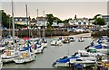
Saundersfoot Harbour, 1971
The stone harbour at Saundersfoot dates from c. 1830 and was connected by railway, run by Saundersfoot Railway and Harbour Co., to local collieries. The Saundersfoot railway closed in 1939 and the last local colliery working was closed in 1950.
Image: © G E Jeal
Taken: Unknown
0.01 miles
2
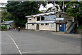
Saundersfoot Sailing Club
At the edge of Saundersfoot Harbour.
Image: © Jaggery
Taken: 16 Jul 2016
0.02 miles
3
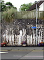
National Cycle Network Route 4 direction and distance sign, Saundersfoot
Alongside the B4316 opposite the Stammers Road junction.
The sign pointing left shows 1 (mile) to Wisemans Bridge, 2 to Amroth.
National Cycle Network Route 4 is a long distance route between London and Fishguard via Reading, Bath, Bristol, Newport, Swansea, Carmarthen, Tenby, Haverfordwest and St Davids.
Image: © Jaggery
Taken: 16 Jul 2016
0.02 miles
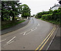
4
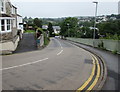
Steep descent towards the centre of Saundersfoot
The road is the B4316 from New Hedges and Tenby.
A nearby gradient sign shows a 12% descent (between 1 in 8 and 1 in 9).
Image: © Jaggery
Taken: 16 Jul 2016
0.02 miles
5
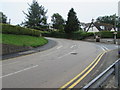
Bend in the B4316, Saundersfoot
This part of the B4316 from Saundersfoot towards Tenby is steep and bendy.
Ahead, past the Stammers Road junction, the B4316 bends through nearly 90 degrees.
A sign http://www.geograph.org.uk/photo/5040242 behind the camera shows a 12% gradient.
Image: © Jaggery
Taken: 16 Jul 2016
0.02 miles
6
Saundersfoot: Across the Harbour
Image: © Mr Eugene Birchall
Taken: 23 Jun 2013
0.02 miles
7
National Cycle Network Route 4 distance sign, Saundersfoot
The blue sign shows 3 (miles) to Tenby. National Cycle Network Route 4 is a long distance route between London and Fishguard via Reading, Bath, Bristol, Newport, Swansea, Carmarthen, Tenby, Haverfordwest and St Davids. Viewed across the B4316 Stammers Road.
Image: © Jaggery
Taken: 16 Jul 2016
0.02 miles
8
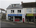
Saundersfoot Laundry Services, Saundersfoot
Viewed in July 2016. This Brewery Terrace shop used to be Saundersfoot Post Office as seen in Chris Downer's August 2010 photo. http://www.geograph.org.uk/photo/2029790
Image: © Jaggery
Taken: 16 Jul 2016
0.02 miles
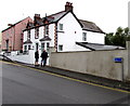
9
No parking on the B4316 in Saundersfoot
Between Stammers Road (behind the camera) and St Bride's Lane,
double yellow lines on both sides of the B4316 indicate no parking at any time
Image: © Jaggery
Taken: 16 Jul 2016
0.02 miles
10
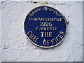
Information Office - The old Coal Offices
In days gone by this building on the seafront was the Coal Offices and the nerve centre for collecting information and data about the stock carried on and by the small train operating to the Saundersfoot docks from the Kilgetty Iron Works and the Grove Colliery. How times have changed as today this same building is the source of information for the tourists .... it is the 'Tourist Information Centre' and the staff there are certainly well informed and helpful Image
Image: © Colin Vosper
Taken: 12 Feb 2010
0.03 miles