IMAGES TAKEN NEAR TO
The Strand, SAUNDERSFOOT, SA69 9ES
Introduction
This page details the photographs taken nearby to The Strand, SA69 9ES by members of the Geograph project.
The Geograph project started in 2005 with the aim of publishing, organising and preserving representative images for every square kilometre of Great Britain, Ireland and the Isle of Man.

There are currently over 7.5m images from over14,400 individuals and you can help contribute to the project by visiting https://www.geograph.org.uk
Image Map (Loading...)


Getting Data...Please wait
Leaflet Map data © OpenStreetMap
Images are licensed for reuse under creativecommons.org/licenses/by-sa/2.0
Notes
- Clicking on the map will re-center to the selected point.
- The higher the marker number, the further away the image location is from the centre of the postcode.
Image Listing (301 Images Found)
Images are licensed for reuse under creativecommons.org/licenses/by-sa/2.0
Image
Details
Distance
1
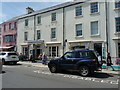
The former Cambrian Hotel building in Saundersfoot
Originally built in the mid/late 1860s as a row of separate houses on Cambrian Terrace; it actually occupies nos 5 and 6 on the street. The whole structure was given a Grade II listing https://www.britishlistedbuildings.co.uk/300006094-cambrian-hotel-saundersfoot in 1970, and is described as being "part of a fine urban group from the period when Saundersfoot was beginning to take on the character of a seaside resort"
It no longer trades as an hotel, the buildings having been converted to houses, apartments and a bar in 2014/15
Image: © Richard Law
Taken: 1 Jun 2017
0.02 miles
2
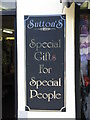
Shop Sign, Saundersfoot
This made my family laugh out loud - go to Saundersfoot and find out why!
Image: © Peter Whatley
Taken: 24 Jul 2009
0.03 miles
4
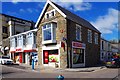
SPAR, 1 The Strand, Saundersfoot, Pembs
Convenience store and off licence, located on the corner of High Street and The Strand. It is one of over 2,500 SPAR branded stores in the UK, although they are not all in the same ownership, as they are operated in the UK on a franchise basis.
Image: © P L Chadwick
Taken: 4 Apr 2015
0.04 miles
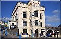
5

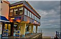
Saundersfoot-The Hean
Public House on High Street.
Image: © Ian Rob
Taken: 1 Jul 2021
0.04 miles
6
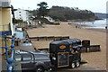
'Horsebox' snack bar, Saundersfoot beach
'Cwlbox' being prepared for service next to base of slipway. Coppet Hall Point is at the far end of the beach; the tide is going out. The tree growing on the rock at the edge of the beach has been shortlisted for Britain's Tree of the Year 2021. It is a Monterey Cypress planted in 1938 and known as 'Saundersfoot's Eiffel Tower'.
Image: © M J Roscoe
Taken: 28 Nov 2021
0.04 miles
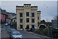
8
The Hean, High Street, Saundersfoot, Pembs
This public house was built in about 1840, with many later alterations. It is a Grade II listed building. It was originally called Picton Castle Inn but by 1887 it had been renamed Hean Castle Hotel. It is now known as The Hean. At the side is a nightclub known as Sands Nightclub.
Image: © L S Wilson
Taken: 4 Apr 2015
0.04 miles
9
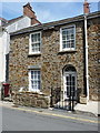
15, The Strand, Saundersfoot
Cottage on The Strand, which was formerly known as Railway Street in recognition of the fact that the old tramway between the collieries up at Begelly and the harbour in Saundersfoot passed along this way. This was operated by the Saundersfoot Railway and Harbour Company between 1830 and 1939.
Image: © Richard Law
Taken: 1 Jun 2017
0.04 miles
10
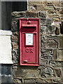
Georgian postbox on The Strand
This is postbox SA69 85D, located on the roadside wall outside Image, and dating from the reign of George V, 1910 to 1936.
Image: © Richard Law
Taken: 1 Jun 2017
0.04 miles