IMAGES TAKEN NEAR TO
SAUNDERSFOOT, SA69 9BG
Introduction
This page details the photographs taken nearby to SA69 9BG by members of the Geograph project.
The Geograph project started in 2005 with the aim of publishing, organising and preserving representative images for every square kilometre of Great Britain, Ireland and the Isle of Man.

There are currently over 7.5m images from over14,400 individuals and you can help contribute to the project by visiting https://www.geograph.org.uk
Image Map (Loading...)


Getting Data...Please wait
Leaflet Map data © OpenStreetMap
Images are licensed for reuse under creativecommons.org/licenses/by-sa/2.0
Notes
- Clicking on the map will re-center to the selected point.
- The higher the marker number, the further away the image location is from the centre of the postcode.
Image Listing (31 Images Found)
Images are licensed for reuse under creativecommons.org/licenses/by-sa/2.0
Image
Details
Distance
1
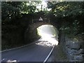
Rail bridge near Saundersfoot station
The railway crosses the B4316 at this location as the road descends to Saundsursfoot.
The ethereal looking (and slightly overexposed) mist seen through the arch is not as it seems - it started life in fact as acrid smelling smoke, as a black plume first observed rising on the other side of the station, rapidly driving us choking off the platform back to the car!
Image: © Hywel Williams
Taken: 29 Jul 2007
0.01 miles
2
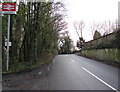
Saundersfoot railway station name sign
On the corner of the B4316 Station Road and the station access road.
Image: © Jaggery
Taken: 6 Jan 2018
0.02 miles
3
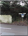
Station Road directions sign near Saundersfoot railway station
The sign facing the station access road https://www.geograph.org.uk/photo/5647636 shows that Saundersfoot is a mile and a quarter (c2km) to the left. The village of Pentlepoir to the right is about 500 metres away. For walkers, this part of the B4316 Station Road is not a pleasant experience. The busy road is narrow and there are no pavements.
Image: © Jaggery
Taken: 6 Jan 2018
0.02 miles
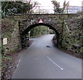
4
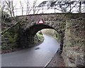
East side of Station Road railway bridge near Pentlepoir
South of Saundersfoot railway station, the 11' 6" headroom stone arch bridge
carries the Pembroke Dock branch of the West Wales Line over the B4316 Station Road.
Image: © Jaggery
Taken: 6 Jan 2018
0.02 miles
5
West side of Station Road railway bridge near Pentlepoir
South of Saundersfoot railway station, the 11' 6" headroom stone arch bridge
carries the Pembroke Dock branch of the West Wales Line over the B4316 Station Road.
The left turn behind the bridge is into the station access road. https://www.geograph.org.uk/photo/5647636
Image: © Jaggery
Taken: 6 Jan 2018
0.02 miles
6
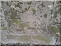
Ordnance Survey Cut Mark
This OS cut mark can be found on the south buttress of the railway bridge. It marks a point 56.905m above mean sea level.
Image: © Adrian Dust
Taken: 7 Apr 2022
0.02 miles
7
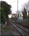
Railway south from Saundersfoot station
Looking past a telecoms mast alongside the single-track Pembroke Dock
branch of the West Wales Line. Next station ahead is Tenby.
Image: © Jaggery
Taken: 6 Jan 2018
0.03 miles
8
Station Road houses near Pentlepoir, Pembrokeshire
On the south side of the B4316 from Saundersfoot to Pentlepoir.
Image: © Jaggery
Taken: 6 Jan 2018
0.04 miles
9
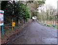
Access road to Saundersfoot railway station
From the north side of the B4316 Station Road.
Image: © Jaggery
Taken: 6 Jan 2018
0.04 miles
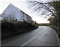
10
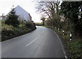
Bend in Station Road towards Pentlepoir
Here named Station Road, the B4316 from Saundersfoot ascends towards Pentlepoir.
Image: © Jaggery
Taken: 6 Jan 2018
0.05 miles