IMAGES TAKEN NEAR TO
Wisemans Bridge, SAUNDERSFOOT, SA69 9AY
Introduction
This page details the photographs taken nearby to SA69 9AY by members of the Geograph project.
The Geograph project started in 2005 with the aim of publishing, organising and preserving representative images for every square kilometre of Great Britain, Ireland and the Isle of Man.

There are currently over 7.5m images from over14,400 individuals and you can help contribute to the project by visiting https://www.geograph.org.uk
Image Map
Images are licensed for reuse under creativecommons.org/licenses/by-sa/2.0
Notes
- Clicking on the map will re-center to the selected point.
- The higher the marker number, the further away the image location is from the centre of the postcode.
Image Listing (77 Images Found)
Images are licensed for reuse under creativecommons.org/licenses/by-sa/2.0
Image
Details
Distance
1
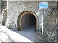
Tunnel - the first of three
This tunnel is the first of three cut through to the beach at Coppet Hall and from there there is one short tunnel through to Saundersfoot. The tunnels were cut to allow the coal, iron and bricks to be transported initially by horse and cart and in later years by steam train to the harbour at Saundersfoot. The main industrial developments were inland (north) of Wiseman's Bridge at Grove Colliery and Kilerry Iron Works. The old miners' train track is now a delightful pedestrian and cycling route.
Image: © Colin Vosper
Taken: 11 Feb 2010
0.09 miles
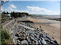
2
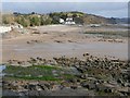
View of the bay at Wiseman's Bridge
Here there is a sandy beach, and a few car-parking spaces that are doubtless much in demand in Summer.
Image: © Humphrey Bolton
Taken: 28 Jan 2010
0.09 miles
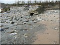
3
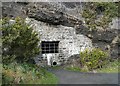
Blocked cave, Saundersfoot
Probably a mine adit. Looking through the bars, a tunnel cut into the rock can be seen. There is another one further south towards Coppet Hall.
Image: © Humphrey Bolton
Taken: 28 Jan 2010
0.09 miles
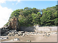
4
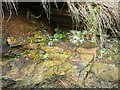
Micro-landscape on the cliff face
The shaly rock supports a growth of yellow-green lichen (or algae), and a grey lichen, and enough soil has been made to support pennywort.
Image: © Humphrey Bolton
Taken: 28 Jan 2010
0.09 miles
5
The Pembrokeshire Coast Path at Wiseman's Bridge
Image: © Dave Kelly
Taken: 5 May 2017
0.11 miles
6
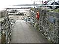
The Cordon Slipway, Wiseman's Bridge
Dedicated to the memory of Councillor Tom Cordon. However it is not much use for boats, as an iron pipe filled with concrete has been set into the ground at the centre of the slipway next to the road.
Image: © Humphrey Bolton
Taken: 28 Jan 2010
0.11 miles
7
Stream across the beach at Wiseman's Bridge
Really a small river. For some reason it is culverted before discharging onto the beach.
Image: © Humphrey Bolton
Taken: 28 Jan 2010
0.11 miles
8

Alternative route near Saundersfoot
An alternative to the coastal path (sometimes closed due to rock falls) is along the cliff top. This route passes through woodland, looking beautiful in early morning mist and with the bluebells out.
Image: © Gareth James
Taken: 20 May 2010
0.11 miles
10
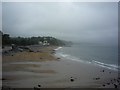
Towards Wiseman's Bridge
Looking along the beach on a wet afternoon.
Image: © DS Pugh
Taken: 30 Aug 2009
0.11 miles