IMAGES TAKEN NEAR TO
Wisemans Bridge, SAUNDERSFOOT, SA69 9AT
Introduction
This page details the photographs taken nearby to SA69 9AT by members of the Geograph project.
The Geograph project started in 2005 with the aim of publishing, organising and preserving representative images for every square kilometre of Great Britain, Ireland and the Isle of Man.

There are currently over 7.5m images from over14,400 individuals and you can help contribute to the project by visiting https://www.geograph.org.uk
Image Map (Loading...)


Getting Data...Please wait
Leaflet Map data © OpenStreetMap
Images are licensed for reuse under creativecommons.org/licenses/by-sa/2.0
Notes
- Clicking on the map will re-center to the selected point.
- The higher the marker number, the further away the image location is from the centre of the postcode.
Image Listing (99 Images Found)
Images are licensed for reuse under creativecommons.org/licenses/by-sa/2.0
Image
Details
Distance
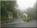
2
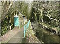
Ford's Lake by public conveniences
The river flows under the coast road and thence into a stone tunnel on the shore Image
Image: © M J Roscoe
Taken: 10 Jan 2022
0.01 miles
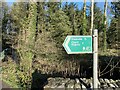
4
The stream upstream of Wiseman's Bridge
A footpath follows the stream, although not shown on the OS map as a right-of-way. Next to it is a discreetly-sited public convenience. It was locked, as so often nowadays, but the area immediately beyond is hidden from the road.
Image: © Humphrey Bolton
Taken: 28 Jan 2010
0.01 miles
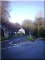
5
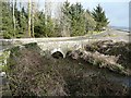
Wiseman's Bridge
The road curves inland a little to cross the stream that runs down Pleasant Valley.
Image: © Humphrey Bolton
Taken: 28 Jan 2010
0.01 miles
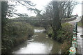
6
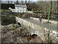
Wiseman's Bridge
There are two stone arches. The main stream goes under the far one, whilst the near one seems to be for a loop through a marshy area. Step Cottage is in the background.
Image: © Humphrey Bolton
Taken: 28 Jan 2010
0.01 miles
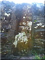
7

Ordnance Survey Cut Mark
This OS cut mark can be found on the south parapet of Wiseman's Bridge. It marks a point 6,689m above mean sea level.
Image: © Adrian Dust
Taken: 7 Apr 2022
0.02 miles
8
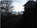
Wiseman's Bridge and Step Cottage
A winter's day - late afternoon. A view from along the track of the old miners' railway line from Grove Colliery to Saundersfoot harbour. Looking passed the bridge one can identify the Monkstone Rocks on the skyline.
Image: © Colin Vosper
Taken: 11 Feb 2010
0.02 miles
9
OS benchmark - Wiseman's Bridge
An OS cutmark on the south parapet of the bridge; originally levelled in 1970 at 6.689m above Ordnance Datum Newlyn.
Image: © Richard Law
Taken: 26 Dec 2019
0.02 miles