IMAGES TAKEN NEAR TO
Castle Graig, SWANSEA, SA6 8NW
Introduction
This page details the photographs taken nearby to Castle Graig, SA6 8NW by members of the Geograph project.
The Geograph project started in 2005 with the aim of publishing, organising and preserving representative images for every square kilometre of Great Britain, Ireland and the Isle of Man.

There are currently over 7.5m images from over14,400 individuals and you can help contribute to the project by visiting https://www.geograph.org.uk
Image Map (Loading...)


Getting Data...Please wait
Leaflet Map data © OpenStreetMap
Images are licensed for reuse under creativecommons.org/licenses/by-sa/2.0
Notes
- Clicking on the map will re-center to the selected point.
- The higher the marker number, the further away the image location is from the centre of the postcode.
Image Listing (31 Images Found)
Images are licensed for reuse under creativecommons.org/licenses/by-sa/2.0
Image
Details
Distance
1
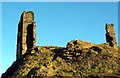
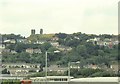
Castell Graig / Morris Castle
Er iddo ddisgwl fel adfail castell o'r Canol Oesoedd adeiladwyd Castell Graig, fel y'i gelwir, rhwng 1768-1775 gan John Morris i gartrefu rhai o'i lowyr a'u teuluodd. Dywedir y bu gan yr adeilad bedwar llawr a 24 o fflatiau. Erbyn 1880 roedd e wedi mynd a'i ben iddo.
Despite having the appearance of a medieval fortification, Morris Castle or Castle Graig, was built between 1768-1775 by John Morris to house some of his colliers and their families. The building consisted of four floors and a total of 24 compartments. It had become ruinous by 1880.
Image: © Alan Richards
Taken: 28 Dec 2008
0.04 miles
2
The ruins of 'Morris Castle' seen from Cwmgelli Close
Image: © john bristow
Taken: 18 Jun 2021
0.04 miles
3
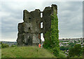
'Morris Castle'
This is actually an apartment block built in the 18th century by local industrialist John Morris to house his workers.
Image: © john bristow
Taken: 18 Jun 2021
0.06 miles
4
'Morris Castle'
This building is not a castle, but was built in the 18th century by local industrialist John Morris to house his workers. It is thought to have accommodated about 40 families.
Image: © john bristow
Taken: 18 Jun 2021
0.06 miles
5
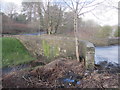
Pont Y Shoot
There is an Ordnance Survey cut mark on the NE parapet. http://www.geograph.org.uk/photo/3823453
Image: © Adrian Dust
Taken: 22 Jan 2014
0.07 miles
6
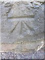
Ordnance Survey Cut Mark
This OS cut mark can be found on the NE parapet of Pont Y Shoot. It marks a point 56.921m above mean sea level. http://www.geograph.org.uk/photo/3823493
Image: © Adrian Dust
Taken: 22 Jan 2014
0.07 miles
8
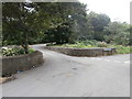
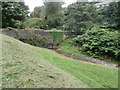
Pont Cwmgelli Bridge
Pont yn rhychwantu Nant y Gelli ger Cnap Llwyd.
A bridge spanning Nant y Gelli Stream near Cnap Llwyd.
Image: © Alan Richards
Taken: 15 Mar 2014
0.08 miles
10
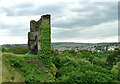
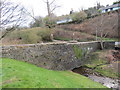
Ruin on Cnap Llwyd, seen from below
The odd corner ruins look like mysterious towers from a distance.
Image: © Nigel Davies
Taken: 31 Jul 2005
0.09 miles