1
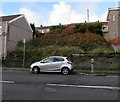
Waste ground above Neath Road, Plasmarl, Swansea
Between Neath Road and Dinas Street.
Image: © Jaggery
Taken: 12 Nov 2018
0.05 miles
2
Steps and path up from Neath Road, Plasmarl, Swansea
Ascending towards Dinas Street.
Image: © Jaggery
Taken: 12 Nov 2018
0.06 miles
3
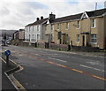
Neath Road houses, Plasmarl, Swansea
Viewed across the B4603 Neath Road.
Image: © Jaggery
Taken: 12 Nov 2018
0.06 miles
4
Row of three houses, Neath Road, Swansea
Set above the B4603 Neath Road.
Image: © Jaggery
Taken: 12 Nov 2018
0.06 miles
5
Dinas Street houses, Plasmarl, Swansea
Houses at the northeast end of Dinas Street viewed across the B4603 Neath Road.
Image: © Jaggery
Taken: 12 Nov 2018
0.06 miles
6
White houses, Neath Road, Swansea
Viewed across the B4603 Neath Road.
Image: © Jaggery
Taken: 12 Nov 2018
0.06 miles
7
Year tablet on the former Ebenezer Methodist chapel, Neath Road, Plasmarl, Swansea
The tablet on this https://www.geograph.org.uk/photo/5988918 building shows
EBENEZER PRIMITIVE METHODIST CHAPEL 1885.
Image: © Jaggery
Taken: 12 Nov 2018
0.07 miles
8
Former Ebenezer Methodist chapel, Neath Road, Plasmarl, Swansea
Derelict building viewed in November 2018. The name tablet https://www.geograph.org.uk/photo/5988919 shows
EBENEZER PRIMITIVE METHODIST CHAPEL 1885.
Image: © Jaggery
Taken: 12 Nov 2018
0.07 miles
9
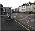
Neath Road bus stop and shelter, Plasmarl, Swansea
This stop near Dinas Street is for buses to the city centre and Swansea bus station.
Image: © Jaggery
Taken: 12 Nov 2018
0.07 miles
10
High numbers near a former chapel, Neath Road, Plasmarl, Swansea
Row of houses on the southwest side of this https://www.geograph.org.uk/photo/5988918 derelict former chapel.
The house on the left is number 1121 Neath Road.
Image: © Jaggery
Taken: 12 Nov 2018
0.07 miles


