IMAGES TAKEN NEAR TO
Idris Terrace, SWANSEA, SA6 8LT
Introduction
This page details the photographs taken nearby to Idris Terrace, SA6 8LT by members of the Geograph project.
The Geograph project started in 2005 with the aim of publishing, organising and preserving representative images for every square kilometre of Great Britain, Ireland and the Isle of Man.

There are currently over 7.5m images from over14,400 individuals and you can help contribute to the project by visiting https://www.geograph.org.uk
Image Map (Loading...)


Getting Data...Please wait
Leaflet Map data © OpenStreetMap
Images are licensed for reuse under creativecommons.org/licenses/by-sa/2.0
Notes
- Clicking on the map will re-center to the selected point.
- The higher the marker number, the further away the image location is from the centre of the postcode.
Image Listing (46 Images Found)
Images are licensed for reuse under creativecommons.org/licenses/by-sa/2.0
Image
Details
Distance
1
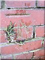
Ordnance Survey Cut Mark
This OS cut mark can be found on the wall of No15 Emlyn Terrace. It marks a point 62.198m above mean sea level.
Image: © Adrian Dust
Taken: 22 Jan 2014
0.07 miles
2
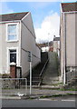
Steps and path up from Neath Road, Plasmarl, Swansea
Ascending towards Dinas Street.
Image: © Jaggery
Taken: 12 Nov 2018
0.08 miles
3
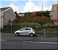
Waste ground above Neath Road, Plasmarl, Swansea
Between Neath Road and Dinas Street.
Image: © Jaggery
Taken: 12 Nov 2018
0.08 miles
4
Dinas Street houses, Plasmarl, Swansea
Houses at the northeast end of Dinas Street viewed across the B4603 Neath Road.
Image: © Jaggery
Taken: 12 Nov 2018
0.09 miles
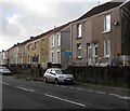
5
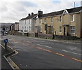
Neath Road houses, Plasmarl, Swansea
Viewed across the B4603 Neath Road.
Image: © Jaggery
Taken: 12 Nov 2018
0.09 miles
6
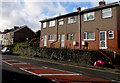
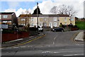
Row of three houses, Neath Road, Swansea
Set above the B4603 Neath Road.
Image: © Jaggery
Taken: 12 Nov 2018
0.09 miles
7
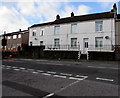
White houses, Neath Road, Swansea
Viewed across the B4603 Neath Road.
Image: © Jaggery
Taken: 12 Nov 2018
0.09 miles
8
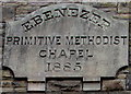
Year tablet on the former Ebenezer Methodist chapel, Neath Road, Plasmarl, Swansea
The tablet on this https://www.geograph.org.uk/photo/5988918 building shows
EBENEZER PRIMITIVE METHODIST CHAPEL 1885.
Image: © Jaggery
Taken: 12 Nov 2018
0.10 miles
9
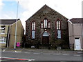
Former Ebenezer Methodist chapel, Neath Road, Plasmarl, Swansea
Derelict building viewed in November 2018. The name tablet https://www.geograph.org.uk/photo/5988919 shows
EBENEZER PRIMITIVE METHODIST CHAPEL 1885.
Image: © Jaggery
Taken: 12 Nov 2018
0.10 miles
10
Houses above Neath Road, Plasmarl, Swansea
Houses on this side of the road are numbered in the three hundreds.
Houses on the opposite side of the road are numbered in the eleven hundreds.
This numbering pattern is boustrophedonic, ie adjacent houses are numbered in sequence.
The usual pattern in the UK is odd numbers on one side, even numbers on the other side.
Image: © Jaggery
Taken: 12 Nov 2018
0.10 miles