IMAGES TAKEN NEAR TO
Bartley Terrace, SWANSEA, SA6 8LN
Introduction
This page details the photographs taken nearby to Bartley Terrace, SA6 8LN by members of the Geograph project.
The Geograph project started in 2005 with the aim of publishing, organising and preserving representative images for every square kilometre of Great Britain, Ireland and the Isle of Man.

There are currently over 7.5m images from over14,400 individuals and you can help contribute to the project by visiting https://www.geograph.org.uk
Image Map
Images are licensed for reuse under creativecommons.org/licenses/by-sa/2.0
Notes
- Clicking on the map will re-center to the selected point.
- The higher the marker number, the further away the image location is from the centre of the postcode.
Image Listing (82 Images Found)
Images are licensed for reuse under creativecommons.org/licenses/by-sa/2.0
Image
Details
Distance
1
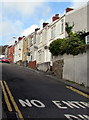
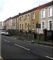
Britannia Road houses, Plasmarl, Swansea
Alongside the ascent from the B4603 Neath Road in the Plasmarl area of Swansea.
Image: © Jaggery
Taken: 12 Nov 2018
0.06 miles
2
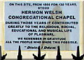
Hermon Welsh Congregational Chapel plaque, Plasmarl, Swansea
The plaque on the wall here https://www.geograph.org.uk/photo/5993218 records that Hermon Welsh Congregational Chapel was on this site for 130 years from 1866.
Image: © Jaggery
Taken: 12 Nov 2018
0.07 miles
3
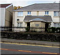
Site of the former Hermon Welsh Congregational Chapel, Plasmarl, Swansea
The plaque https://www.geograph.org.uk/photo/5993219 on the wall of a Neath Road house records that Hermon Welsh Congregational Chapel was on this site for 130 years from 1866.
Image: © Jaggery
Taken: 12 Nov 2018
0.07 miles
4
Site of the former Plasmarl Sunday School, Neath Road, Swansea
A plaque https://www.geograph.org.uk/photo/5993216 on the wall behind the car shows PLAS MARL SUNDAY SCHOOL 1867.
Image: © Jaggery
Taken: 12 Nov 2018
0.08 miles
5
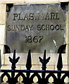
Plas Marl Sunday School 1867 plaque, Neath Road, Swansea
On the wall behind the car here. https://www.geograph.org.uk/photo/5993215
Image: © Jaggery
Taken: 12 Nov 2018
0.08 miles
6
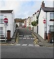
Up Britannia Road, Plasmarl, Swansea
Britannia Road ascends from the B4603 Neath Road in the Plasmarl area of Swansea.
Image: © Jaggery
Taken: 12 Nov 2018
0.08 miles
7
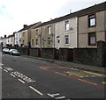
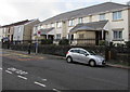
Neath Road houses, Plasmarl, Swansea
Houses set above the B4603 Neath Road, accessed by steps.
Image: © Jaggery
Taken: 12 Nov 2018
0.08 miles
8
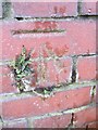
Ordnance Survey Cut Mark
This OS cut mark can be found on the wall of No15 Emlyn Terrace. It marks a point 62.198m above mean sea level.
Image: © Adrian Dust
Taken: 22 Jan 2014
0.08 miles
9
Row of houses above Neath Road, Plasmarl, Swansea
Accessed by steps, the houses are set above the B4603 Neath Road.
Image: © Jaggery
Taken: 12 Nov 2018
0.09 miles
10
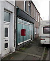
Queen Elizabeth II postbox outside a former post office, Neath Road, Plasmarl, Swansea
In November 2018, the postbox is a reminder that the vacant unnamed shop used to be a post office.
Image: © Jaggery
Taken: 12 Nov 2018
0.09 miles