IMAGES TAKEN NEAR TO
Salem Road, SWANSEA, SA6 8LB
Introduction
This page details the photographs taken nearby to Salem Road, SA6 8LB by members of the Geograph project.
The Geograph project started in 2005 with the aim of publishing, organising and preserving representative images for every square kilometre of Great Britain, Ireland and the Isle of Man.

There are currently over 7.5m images from over14,400 individuals and you can help contribute to the project by visiting https://www.geograph.org.uk
Image Map
Images are licensed for reuse under creativecommons.org/licenses/by-sa/2.0
Notes
- Clicking on the map will re-center to the selected point.
- The higher the marker number, the further away the image location is from the centre of the postcode.
Image Listing (103 Images Found)
Images are licensed for reuse under creativecommons.org/licenses/by-sa/2.0
Image
Details
Distance
1
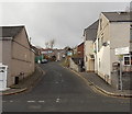
Salem Road, Swansea
Viewed from Neath Road in the Plasmarl area of Swansea.
Image: © Jaggery
Taken: 6 Dec 2013
0.01 miles
2
St John Ambulance building, Salem Road, Swansea
Located opposite Calland Street in the Plasmarl area of Swansea.
Image: © Jaggery
Taken: 6 Dec 2013
0.01 miles
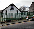
3
St John Ambulance hall, Salem Road, Swansea
Located opposite Calland Street in the Plasmarl area of Swansea.
Image: © Jaggery
Taken: 12 Nov 2018
0.01 miles
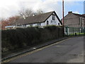
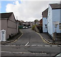
4
Corner of Salem Road and Calland Street, Swansea
In the Plasmarl area of Swansea.
Image: © Jaggery
Taken: 6 Dec 2013
0.01 miles
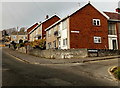
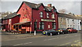
5
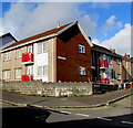
Red balconies on a Plasmarl corner, Swansea
On the corner of Salem Road and Calland Street in the Plasmarl area of Swansea.
Image: © Jaggery
Taken: 12 Nov 2018
0.02 miles
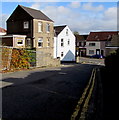
6
Junction of Neath Road and Salem Road, Plasmarl, Swansea
Salem Road ascends from the west side of the B4603 Neath Road in the Plasmarl area of Swansea.
Image: © Jaggery
Taken: 12 Nov 2018
0.02 miles
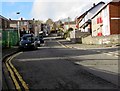
7
Down Salem Road, Plasmarl, Swansea
Salem Road descends towards the B4603 Neath Road in the Plasmarl area of Swansea.
Image: © Jaggery
Taken: 12 Nov 2018
0.04 miles
8
Up Salem Road, Plasmarl, Swansea
Salem Road ascends past the right turn into Calland Street. https://www.geograph.org.uk/photo/5974326
Image: © Jaggery
Taken: 12 Nov 2018
0.04 miles
9
The Coopers Arms, Swansea
A Brains pub alongside Neath Road in the Plasmarl area of Swansea. Viewed in December 2013.
Update The pub has a difference appearance https://www.geograph.org.uk/photo/5975664 in November 2018.
Image: © Jaggery
Taken: 6 Dec 2013
0.04 miles
10
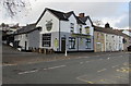
Coopers Arms, Plasmarl, Swansea
Pub at 287 Neath Road in the Plasmarl area of Swansea, viewed in November 2018.
This https://www.geograph.org.uk/photo/3844331 is how the pub looked in December 2013.
Image: © Jaggery
Taken: 12 Nov 2018
0.04 miles