IMAGES TAKEN NEAR TO
Ash Street, SWANSEA, SA6 8HD
Introduction
This page details the photographs taken nearby to Ash Street, SA6 8HD by members of the Geograph project.
The Geograph project started in 2005 with the aim of publishing, organising and preserving representative images for every square kilometre of Great Britain, Ireland and the Isle of Man.

There are currently over 7.5m images from over14,400 individuals and you can help contribute to the project by visiting https://www.geograph.org.uk
Image Map
Images are licensed for reuse under creativecommons.org/licenses/by-sa/2.0
Notes
- Clicking on the map will re-center to the selected point.
- The higher the marker number, the further away the image location is from the centre of the postcode.
Image Listing (80 Images Found)
Images are licensed for reuse under creativecommons.org/licenses/by-sa/2.0
Image
Details
Distance
1
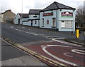
Swan Inn, Morriston, Swansea
The Martin Street side of the pub at 564 Neath Road. https://www.geograph.org.uk/photo/5973466 to a closer view of the name sign.
Image: © Jaggery
Taken: 12 Nov 2018
0.06 miles
2
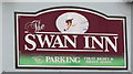
Swan Inn name sign, Morriston, Swansea
On the wall here. https://www.geograph.org.uk/photo/5973462
Image: © Jaggery
Taken: 12 Nov 2018
0.06 miles
3
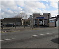
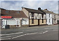
EuroBlinds, 30 Martin Street, Swansea
Viewed across the B4603 in the Morriston area of Swansea.
Image: © Jaggery
Taken: 12 Nov 2018
0.06 miles
4
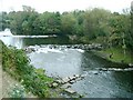
Weirs on the river Tawe
Taken from the high west bank near a residential street. There is a cycle path along the east bank which can be joined from Ferryboat road. The difference in height between the banks here makes me question whether there was ever really a ferry though.
Image: © Nigel Davies
Taken: 14 Oct 2007
0.06 miles
5
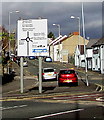
Directions sign at the edge of a major junction in Swansea
Alongside the B4603 near the roundabout at the A4067 junction.
The Swan Inn https://www.geograph.org.uk/photo/5973462 is on the right.
Image: © Jaggery
Taken: 12 Nov 2018
0.08 miles
6
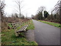
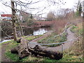
Llwybr beicio ger Treforus / Cycle path near Morriston
Llwybr becio ar lan Afon Tawe ger Treforus.
A cycle path above the Tawe river near Morriston.
Image: © Alan Richards
Taken: 8 Jan 2020
0.08 miles
7
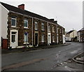
Row of stone houses, Market Street, Morriston, Swansea
On the east side of the street viewed from the corner of Banwell Street looking south.
The sign on the left shows that the road ahead is not a through route for motor vehicles.
Image: © Jaggery
Taken: 16 Oct 2018
0.08 miles
8
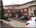
St Martin's Lodge, Morriston, Swansea
Set back from the west side of the B4603 Martin Street.
Image: © Jaggery
Taken: 12 Nov 2018
0.09 miles
9
Sky Step takeaway in Morriston, Swansea
Chinese takeaway at 557 Neath Road on the corner of Clyndu Street.
Image: © Jaggery
Taken: 12 Nov 2018
0.09 miles
10
Llwybr i'r afon / Path to the river
Llwybr yn arwain i lawr o'r trac beicio at lannau Afon Tawe.
A path leading down from the cycle track towards the banks of the Tawe River.
Image: © Alan Richards
Taken: 8 Jan 2020
0.09 miles