IMAGES TAKEN NEAR TO
Glantawe Street, SWANSEA, SA6 8BP
Introduction
This page details the photographs taken nearby to Glantawe Street, SA6 8BP by members of the Geograph project.
The Geograph project started in 2005 with the aim of publishing, organising and preserving representative images for every square kilometre of Great Britain, Ireland and the Isle of Man.

There are currently over 7.5m images from over14,400 individuals and you can help contribute to the project by visiting https://www.geograph.org.uk
Image Map (Loading...)


Getting Data...Please wait
Leaflet Map data © OpenStreetMap
Images are licensed for reuse under creativecommons.org/licenses/by-sa/2.0
Notes
- Clicking on the map will re-center to the selected point.
- The higher the marker number, the further away the image location is from the centre of the postcode.
Image Listing (84 Images Found)
Images are licensed for reuse under creativecommons.org/licenses/by-sa/2.0
Image
Details
Distance
1
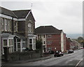
East along Crown Street, Morriston, Swansea
Crown Street descends towards Glantawe Street and Green Street.
Image: © Jaggery
Taken: 16 Oct 2018
0.02 miles
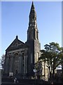
2
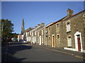
Crown St, Morriston
Capel y Tabernacl can be seen at the far end of the street
Image: © John Lord
Taken: 17 Oct 2009
0.04 miles
3

South side of Capel y Tabernacl, Morriston, Swansea
Crown Street side of this https://www.geograph.org.uk/photo/6194311 Grade I listed chapel.
Image: © Jaggery
Taken: 16 Oct 2018
0.05 miles
5
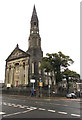
Grade I Listed Capel y Tabernacl, Morriston, Swansea
This large chapel built in 1870-1872 is known as the Cathedral of Welsh Nonconformity. It was originally New Libanus Chapel. The building was Grade I listed in 1993 as perhaps the most ambitious grand chapel in Wales with a striking exterior presence and virtually unaltered interior and fittings.
Image: © Jaggery
Taken: 16 Oct 2018
0.05 miles
6
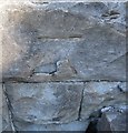
Ordnance Survey Cut Mark
This OS cut mark can be found on the south face of the Tabernacle Chapel. It marks a point 34.138m above mean sea level.
Image: © Adrian Dust
Taken: 20 Sep 2016
0.05 miles
7
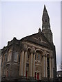
Morriston Chapel
On Woodfield Street. Known as Capel Y Tabernacl or Libanus Chapel. Also as the Nonconformist Cathedral of Wales. Built in 1872 for £15,000. Designed by John Humphrey. Grade I Listed. The Ordnance Survey used the Spire as a 3rd Order Triangulation Point (Intersected Station SN80/INT016).
Image: © Adrian Dust
Taken: 31 Mar 2012
0.05 miles
9
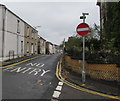
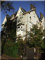
One-way Glantawe Street, Morriston, Swansea
Derelict Danbert House https://www.geograph.org.uk/photo/5944186 is on the right.
Image: © Jaggery
Taken: 16 Oct 2018
0.06 miles
10
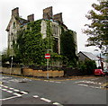
Overgrown Danbert House in Morriston, Swansea
The Grade II listed derelict building is on the corner of Morfydd Street and Glantawe Street.
The Cadw website records that the house was built in the 1880s for, and probably designed by, Daniel Edwards (1835-1915), tinplate manufacturer of Morriston. Danbert was a brand name for a type of tinplate made at his Dyffryn Works. House construction was not completed because of the bankruptcy of the builder, and Edwards never lived here. The building was at some time an Employment Exchange.
The building was Grade II listed in 1993 as "a well-preserved example of a large Victorian town house, rare in Morriston". I wonder when "well-preserved" ceased to apply...
Image: © Jaggery
Taken: 16 Oct 2018
0.06 miles