IMAGES TAKEN NEAR TO
Clos Yr Orsaf, SWANSEA, SA6 8BJ
Introduction
This page details the photographs taken nearby to Clos Yr Orsaf, SA6 8BJ by members of the Geograph project.
The Geograph project started in 2005 with the aim of publishing, organising and preserving representative images for every square kilometre of Great Britain, Ireland and the Isle of Man.

There are currently over 7.5m images from over14,400 individuals and you can help contribute to the project by visiting https://www.geograph.org.uk
Image Map (79 Images)


Getting Data...Please wait
Leaflet Map data © OpenStreetMap
Images are licensed for reuse under creativecommons.org/licenses/by-sa/2.0
Notes
- Clicking on the map will re-center to the selected point.
- The higher the marker number, the further away the image location is from the centre of the postcode.
Image Listing (79 Images Found)
Images are licensed for reuse under creativecommons.org/licenses/by-sa/2.0
Image
Details
Distance
2
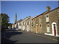
Crown St, Morriston
Capel y Tabernacl can be seen at the far end of the street
Image: © John Lord
Taken: 17 Oct 2009
0.06 miles
3
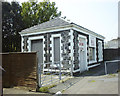
Former Morriston West Station (Clase Road)
This building on Clase Road housed the ticket office for the Great Western Railway's Morriston West Station. It opened in May 1881 and closed to passengers in June 1956. The line closed completely in October 1965. It became a shop for a number of years after closure. The running lines ran under the road - today the station area is a car park.
This view was taken in 1998 when the structure was relatively unmodified. Today, the structure still stands, although an extra storey and a side extension have been added.
The grainy image quality was due to the use of an early digital camera (Fuji MX700)
Image: © vectorkraft
Taken: 8 May 1998
0.06 miles
4
Former Morriston West Station (Foundry Road)
This 1998 view shows the paths of the former running lines from Foundry Road through to the old platform site. Morriston West Station was situated on the viaduct on Clase Road. The station building is still extant.
It opened in May 1881 and closed to passengers in June 1956. The line closed completely in October 1965. The station became a shop for a number of years after closure.
The grainy image quality was due to the use of an early digital camera (Fuji MX700)
Image: © vectorkraft
Taken: 8 May 1998
0.06 miles
5
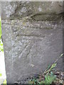
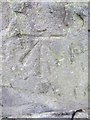
Ordnance Survey Cut Mark
This OS cut mark can be found on the SW buttress of the old railway bridge. It marks a point 21.446m above mean sea level.
Image: © Adrian Dust
Taken: 3 Jun 2015
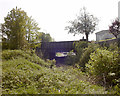
0.06 miles
6
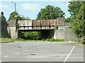
A48 crosses former Swansea Vale Railway at Morriston
The west branch of the Vale railway is long gone (and the last short remnant of the disused eastern one is being torn up right now). The land here has been reused as the carpark for Castle Bingo.
I had originally thought that this bridge was for the old Swansea Canal but Lee Hanford wrote to set me straight.
Examining the old maps I have to agree that the canal and railway were separate here and that the canal was a little further east.
The eastern branch of the old railway can be seen here: Image] Image]
Image: © Nigel Davies
Taken: 30 May 2009
0.07 miles
7
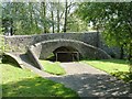
Former canal bridge over Morriston footpath
The Swansea Canal is no more. At this point it has become a footpath. You'll have to stoop to pass under the bridge since the canal has been completely filled in.
Image: © Nigel Davies
Taken: 30 May 2009
0.09 miles
8
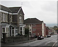
East along Crown Street, Morriston, Swansea
Crown Street descends towards Glantawe Street and Green Street.
Image: © Jaggery
Taken: 16 Oct 2018
0.10 miles
9
Ordnance Survey Cut Mark
This OS cut mark can be found on the north buttress of the old railway bridge on Morfydd Street. It marks a point 20.163m above mean sea level.
Image: © Adrian Dust
Taken: 28 Jan 2014
0.11 miles
10
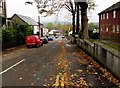
Eastern end of Morfydd Street, Morriston, Swansea
Flats in Jim Havard Court are on the right. In the distance, Morfydd Street ends at a wall at the edge of the A4067.
Image: © Jaggery
Taken: 16 Oct 2018
0.11 miles