IMAGES TAKEN NEAR TO
Carmarthen Road, KILGETTY, SA68 0YB
Introduction
This page details the photographs taken nearby to Carmarthen Road, SA68 0YB by members of the Geograph project.
The Geograph project started in 2005 with the aim of publishing, organising and preserving representative images for every square kilometre of Great Britain, Ireland and the Isle of Man.

There are currently over 7.5m images from over14,400 individuals and you can help contribute to the project by visiting https://www.geograph.org.uk
Image Map (Loading...)


Getting Data...Please wait
Leaflet Map data © OpenStreetMap
Images are licensed for reuse under creativecommons.org/licenses/by-sa/2.0
Notes
- Clicking on the map will re-center to the selected point.
- The higher the marker number, the further away the image location is from the centre of the postcode.
Image Listing (73 Images Found)
Images are licensed for reuse under creativecommons.org/licenses/by-sa/2.0
Image
Details
Distance
1
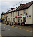
Kilgetty Post Office
In January 2018 the village post office is in Bridge Stores, Carmarthen Road, Kilgetty.
Image: © Jaggery
Taken: 6 Jan 2018
0.00 miles
2
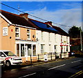
Bridge Caff, Carmarthen Road, Kilgetty
On the left, the cafe named Bridge Caff (eat in or take away) opened here in November 2017.
An August 2016 Google Earth Street View shows a fabrics shop here.
The village post office is in Bridge Stores on the right. https://www.geograph.org.uk/photo/5646333
Image: © Jaggery
Taken: 19 Jan 2018
0.01 miles
3
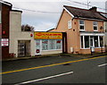
Kilgetty Cycle Centre, Kilgetty
Viewed across Carmarthen Road.
Image: © Jaggery
Taken: 6 Jan 2018
0.01 miles
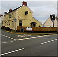
4
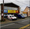
Bumper to Bumper in Kilgetty
Motor factor viewed across Carmarthen Road. Motor factors sell car parts and accessories.
Image: © Jaggery
Taken: 6 Jan 2018
0.01 miles
5
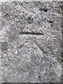
Ordnance Survey Cut Mark
This OS cut mark can be found on the NW face of the railway bridge. It marks a point 69.178m above mean sea level.
Image: © Adrian Dust
Taken: 26 May 2014
0.01 miles
6
White Horse name signs, Kilgetty
Two signs located here. https://www.geograph.org.uk/photo/5646351
Image: © Jaggery
Taken: 6 Jan 2018
0.02 miles
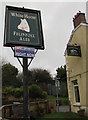
7
White Horse, Kilgetty
The pub on the corner of Station Road and Carmarthen Road used to be the Railway Inn.
Image: © Jaggery
Taken: 6 Jan 2018
0.02 miles
8

Kilgetty Railway
Railway line and station at Kilgetty, towards Narberth.
Image: © Alan Hughes
Taken: 12 Jan 2022
0.02 miles
9
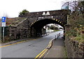
West side of Carmarthen Road railway bridge, Kilgetty
Headroom shown over the middle part of the bridge is 13' 0" and 3.96 metres.
Traffic on this side has priority over oncoming vehicles.
Double yellow lines on both sides indicate no parking at any time.
Image: © Jaggery
Taken: 6 Jan 2018
0.02 miles
10

OS benchmark - Kilgetty, railway bridge buttress
An OS cutmark on the NW face of the railway bridge buttress; originally levelled in 1970 at 69.178m above Ordnance Datum Newlyn.
Image: © Richard Law
Taken: 24 Dec 2019
0.02 miles