IMAGES TAKEN NEAR TO
Begelly, KILGETTY, SA68 0XL
Introduction
This page details the photographs taken nearby to SA68 0XL by members of the Geograph project.
The Geograph project started in 2005 with the aim of publishing, organising and preserving representative images for every square kilometre of Great Britain, Ireland and the Isle of Man.

There are currently over 7.5m images from over14,400 individuals and you can help contribute to the project by visiting https://www.geograph.org.uk
Image Map (Loading...)


Getting Data...Please wait
Leaflet Map data © OpenStreetMap
Images are licensed for reuse under creativecommons.org/licenses/by-sa/2.0
Notes
- Clicking on the map will re-center to the selected point.
- The higher the marker number, the further away the image location is from the centre of the postcode.
Image Listing (3 Images Found)
Images are licensed for reuse under creativecommons.org/licenses/by-sa/2.0
Image
Details
Distance
1
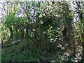
Abandoned Building at Thomas Chapel Colliery
For more information go to www.welshcoalmines.co.uk/Carm/thomas-chapel.htm
Image: © Rob Lowe
Taken: 29 Apr 2009
0.15 miles
2
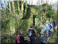
Hen adfail / Old Ruin
Cerddwyr yn mynd heibio i adfail wrth ddilyn Ffordd y Glowyr.
Walkers passing a ruined building while following the Miners Trail.
Image: © Alan Richards
Taken: 1 Mar 2009
0.15 miles
3
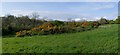
Remains of New Hayes Colliery
To the right of the picture you can see fenced off area of collapse repair. For more information go to www.welshcoalmines.co.uk/Carm/thomas-chapel.htm
Image: © Rob Lowe
Taken: 28 Apr 2009
0.17 miles