IMAGES TAKEN NEAR TO
Whitehill, KILGETTY, SA68 0TX
Introduction
This page details the photographs taken nearby to Whitehill, SA68 0TX by members of the Geograph project.
The Geograph project started in 2005 with the aim of publishing, organising and preserving representative images for every square kilometre of Great Britain, Ireland and the Isle of Man.

There are currently over 7.5m images from over14,400 individuals and you can help contribute to the project by visiting https://www.geograph.org.uk
Image Map
Images are licensed for reuse under creativecommons.org/licenses/by-sa/2.0
Notes
- Clicking on the map will re-center to the selected point.
- The higher the marker number, the further away the image location is from the centre of the postcode.
Image Listing (3 Images Found)
Images are licensed for reuse under creativecommons.org/licenses/by-sa/2.0
Image
Details
Distance
1
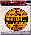
Old circular AA Sign in Whitehill
Old AA Sign on the front garden wall of The Gables on the northeast side of the road in Whitehill, 5½ miles northeast of Pembroke. Carew Community.
This is the circular, village name on black band, no Motor Union symbol or name type, dating from 1923, and showing distances Cresswell 1¼ Pembroke 5½ London 239¾.
There were five series of AA signs, mostly dating from 1923 and made by Francis & Co / Franco in Deptford, London. The village name and distance to London were usually displayed.
See also https://www.flickr.com/photos/walsh01/4086672646 , https://www.flickr.com/photos/9090635@N03/1031515205 and https://www.flickr.com/photos/93410621@N05/13905492822.
Milestone Society National ID: PEM-WHITE
Image: © Milestone Society
Taken: Unknown
0.10 miles
3
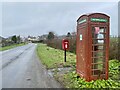
Post box and old phone box
Village facilities on the edge of Whitehill.
Image: © Alan Hughes
Taken: 27 Feb 2024
0.20 miles