IMAGES TAKEN NEAR TO
Cresselly, KILGETTY, SA68 0TS
Introduction
This page details the photographs taken nearby to SA68 0TS by members of the Geograph project.
The Geograph project started in 2005 with the aim of publishing, organising and preserving representative images for every square kilometre of Great Britain, Ireland and the Isle of Man.

There are currently over 7.5m images from over14,400 individuals and you can help contribute to the project by visiting https://www.geograph.org.uk
Image Map (Loading...)


Getting Data...Please wait
Leaflet Map data © OpenStreetMap
Images are licensed for reuse under creativecommons.org/licenses/by-sa/2.0
Notes
- Clicking on the map will re-center to the selected point.
- The higher the marker number, the further away the image location is from the centre of the postcode.
Image Listing (3 Images Found)
Images are licensed for reuse under creativecommons.org/licenses/by-sa/2.0
Image
Details
Distance
1
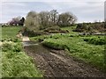
River Carew Ford
This ford and stepping stones are found on the River Carew near to Crickchurch Farm at Sageston.
Image: © John Walton
Taken: 15 Apr 2019
0.13 miles
2

Bartlett Engineering Co., Sageston
Bartlett Engineering Co. first opened it's workshops over 40 years ago.
Image: © Deborah Tilley
Taken: 23 Apr 2016
0.24 miles
3
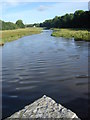
Carew River upstream from the bridge
Image: © Ruth Sharville
Taken: 14 Aug 2008
0.25 miles