IMAGES TAKEN NEAR TO
West Williamston, KILGETTY, SA68 0TL
Introduction
This page details the photographs taken nearby to SA68 0TL by members of the Geograph project.
The Geograph project started in 2005 with the aim of publishing, organising and preserving representative images for every square kilometre of Great Britain, Ireland and the Isle of Man.

There are currently over 7.5m images from over14,400 individuals and you can help contribute to the project by visiting https://www.geograph.org.uk
Image Map (Loading...)


Getting Data...Please wait
Leaflet Map data © OpenStreetMap
Images are licensed for reuse under creativecommons.org/licenses/by-sa/2.0
Notes
- Clicking on the map will re-center to the selected point.
- The higher the marker number, the further away the image location is from the centre of the postcode.
Image Listing (8 Images Found)
Images are licensed for reuse under creativecommons.org/licenses/by-sa/2.0
Image
Details
Distance
2
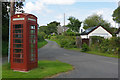
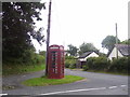
West Williamston
There is not much to West Williamston, but this decidedly off-the-beaten-track hamlet boasts a working telephone box. It was photographed for Geograph twice in 2016 and it is still here a year later. It would be interesting to know how much use it has had in that time.
Image: © Stephen McKay
Taken: 31 Aug 2017
0.05 miles
3

The Centre Of West Williamston!
A tiny village in Pembrokeshire.
Image: © Deborah Tilley
Taken: 23 Apr 2016
0.06 miles

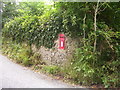
6
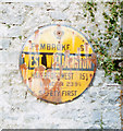
Old circular AA sign on Rosemary Lane in West Williamston
Old AA Sign located on the south facing stone gable end of a barn on Rosemary Lane in West Williamston, 4½ miles northeast of Pembroke. Carew community.
This is the circular, village name on black band, no Motor Union symbol or name type, dating from 1923, and showing distances Pembroke 5¼ Haverfordwest 15¾ London 239¾.
There were five series of AA signs, mostly dating from 1923 and made by Francis & Co / Franco in Deptford, London. The village name and distance to London or Dublin were normally displayed.
See also http://www.geograph.org.uk/photo/5096574.
Milestone Society National ID: PEM-WWILL
Image: © Milestone Society
Taken: Unknown
0.08 miles
7
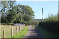
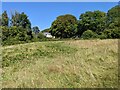
End of private road from Williamston Park
The road is also the public footpath from West Williamston nature reserve. The parking area, centre left, is not shown on the current OS map. For view from the vehicle park - Image
Image: © M J Roscoe
Taken: 16 Aug 2023
0.11 miles