IMAGES TAKEN NEAR TO
Millfields Close, KILGETTY, SA68 0SA
Introduction
This page details the photographs taken nearby to Millfields Close, SA68 0SA by members of the Geograph project.
The Geograph project started in 2005 with the aim of publishing, organising and preserving representative images for every square kilometre of Great Britain, Ireland and the Isle of Man.

There are currently over 7.5m images from over14,400 individuals and you can help contribute to the project by visiting https://www.geograph.org.uk
Image Map (Loading...)


Getting Data...Please wait
Leaflet Map data © OpenStreetMap
Images are licensed for reuse under creativecommons.org/licenses/by-sa/2.0
Notes
- Clicking on the map will re-center to the selected point.
- The higher the marker number, the further away the image location is from the centre of the postcode.
Image Listing (32 Images Found)
Images are licensed for reuse under creativecommons.org/licenses/by-sa/2.0
Image
Details
Distance
1
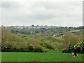
Pentlepoir and Surrounding Countryside
Pentlepoir and surrounding countryside taken from footpath just outside the village of East Williamston
Image: © Rob Lowe
Taken: 20 May 2009
0.08 miles
2
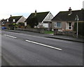
Pentlepoir bungalows
Viewed across the A478, the main road through the Pembrokeshire village.
Image: © Jaggery
Taken: 6 Jan 2018
0.08 miles
3
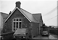
Pentlepoir Youth Hostel
Pentlepoir Youth Hostel in March 1987. This former school was open as a youth hostel from 1972 to 1999.
Image: © Philip Halling
Taken: 21 Mar 1987
0.09 miles
4
Western Power Distribution electricity substation alongside the A487 in Pentlepoir
Substation S/S 604737 is near the Green Park junction on the left.
Image: © Jaggery
Taken: 6 Jan 2018
0.10 miles
5
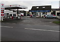
Pentlepoir Services Lifestyle Express shop, Pentlepoir
Set back from the A478. Pentlepoir Garage https://www.geograph.org.uk/photo/5645735 is on the left.
Image: © Jaggery
Taken: 6 Jan 2018
0.10 miles
6
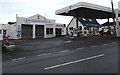
Pentlepoir Garage, Pentlepoir
Viewed across the A478. Pentlepoir Services Lifestyle Express shop https://www.geograph.org.uk/photo/5645727 is on the right.
Image: © Jaggery
Taken: 6 Jan 2018
0.11 miles
7
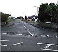
Junction of the A478 and Hawthorn Close, Pentlepoir
Hawthorn Close https://www.geograph.org.uk/photo/5645673 ascends from the east side of the A478.
Image: © Jaggery
Taken: 6 Jan 2018
0.11 miles
8
Muddy access to a public footpath, Pentlepoir
From a kissing gate https://www.geograph.org.uk/photo/5647605 alongside the A478, the main road through the village. Viewed in January 2018.
Image: © Jaggery
Taken: 6 Jan 2018
0.12 miles
9
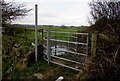
Kissing gate to a public footpath, Pentlepoir
The gate alongside the A478 gives across to a public footpath through this field. https://www.geograph.org.uk/photo/5647604
Image: © Jaggery
Taken: 6 Jan 2018
0.13 miles
10
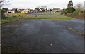
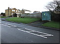
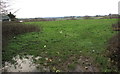
Site of the demolished former primary school in Pentlepoir
Viewed from the edge of the A487 in January 2018.
Pentlepoir County Primary School which was on this site closed about a decade ago.
Image: © Jaggery
Taken: 6 Jan 2018
0.13 miles