IMAGES TAKEN NEAR TO
Lyndhurst Avenue, KILGETTY, SA68 0RZ
Introduction
This page details the photographs taken nearby to Lyndhurst Avenue, SA68 0RZ by members of the Geograph project.
The Geograph project started in 2005 with the aim of publishing, organising and preserving representative images for every square kilometre of Great Britain, Ireland and the Isle of Man.

There are currently over 7.5m images from over14,400 individuals and you can help contribute to the project by visiting https://www.geograph.org.uk
Image Map
Images are licensed for reuse under creativecommons.org/licenses/by-sa/2.0
Notes
- Clicking on the map will re-center to the selected point.
- The higher the marker number, the further away the image location is from the centre of the postcode.
Image Listing (10 Images Found)
Images are licensed for reuse under creativecommons.org/licenses/by-sa/2.0
Image
Details
Distance
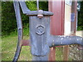
2
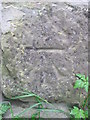
Ordnance Survey Cut Mark
This OS cut mark can be found on the stone gatepost to Hanbury Lodge. It marks a point 52.014m above mean sea level.
Image: © Adrian Dust
Taken: 26 May 2014
0.18 miles
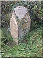
5
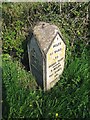
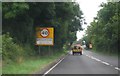
Old Milestone by the A477, near Broadmoor
Pembroke double plate by the A477, in parish of East Williamston (Pembrokeshire District).
Inscription reads:-
: 24 MILES / TO / CARMARTHEN : : 9 / MILES / 85 YARDS / TO / HOBBS POINT / 7 MILES / 320 YARDS / TO / PEMBROKE :
Surveyed
Milestone Society National ID: PEM_CMHP24
Image: © Milestone Society
Taken: Unknown
0.21 miles
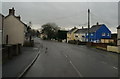
6
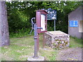
Village Pump and Information Board, Broadmoor
Image: © welshbabe
Taken: 18 Jun 2015
0.22 miles
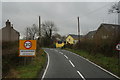
10
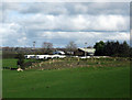
Caravan storage site at Upper Masterland
Taken from the B4586
Image: © Phil Johnstone
Taken: 27 Oct 2008
0.23 miles