IMAGES TAKEN NEAR TO
Jeffreyston, KILGETTY, SA68 0RG
Introduction
This page details the photographs taken nearby to SA68 0RG by members of the Geograph project.
The Geograph project started in 2005 with the aim of publishing, organising and preserving representative images for every square kilometre of Great Britain, Ireland and the Isle of Man.

There are currently over 7.5m images from over14,400 individuals and you can help contribute to the project by visiting https://www.geograph.org.uk
Image Map
Images are licensed for reuse under creativecommons.org/licenses/by-sa/2.0
Notes
- Clicking on the map will re-center to the selected point.
- The higher the marker number, the further away the image location is from the centre of the postcode.
Image Listing (32 Images Found)
Images are licensed for reuse under creativecommons.org/licenses/by-sa/2.0
Image
Details
Distance
1
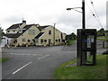
Village Pub & Telephone Box, Jeffreyston
Image: © Peter Whatley
Taken: 21 Jul 2009
0.08 miles
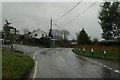
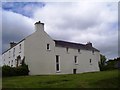
4
Jeffreyston House
This is near to the entrance to the churchyard.
Image: © Humphrey Bolton
Taken: 30 Aug 2020
0.13 miles
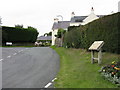
5
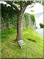
Jeffreyston Church -. Oswald & St. Jeffrey - ornamental cherry tree
Image: © welshbabe
Taken: 21 May 2015
0.14 miles
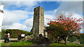
7
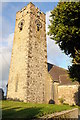
Jeffreyston church
The parish church of Jeffreyston is dedicated to St Oswald and St Jeffrey.
Image: © Philip Halling
Taken: 17 Sep 2011
0.14 miles
9
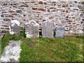
Jeffreyston Church -. Oswald & St. Jeffrey - graves by church
Image: © welshbabe
Taken: 21 May 2015
0.15 miles
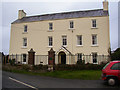
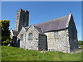
10
Jeffreyston - Church of St Jeffrey & St Oswald
Image: © Colin Park
Taken: 13 Oct 2022
0.15 miles