IMAGES TAKEN NEAR TO
Rock Park, KILGETTY, SA68 0AB
Introduction
This page details the photographs taken nearby to Rock Park, SA68 0AB by members of the Geograph project.
The Geograph project started in 2005 with the aim of publishing, organising and preserving representative images for every square kilometre of Great Britain, Ireland and the Isle of Man.

There are currently over 7.5m images from over14,400 individuals and you can help contribute to the project by visiting https://www.geograph.org.uk
Image Map
Images are licensed for reuse under creativecommons.org/licenses/by-sa/2.0
Notes
- Clicking on the map will re-center to the selected point.
- The higher the marker number, the further away the image location is from the centre of the postcode.
Image Listing (37 Images Found)
Images are licensed for reuse under creativecommons.org/licenses/by-sa/2.0
Image
Details
Distance
1
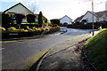
Kilvelgy Park, Kilgetty
Cul-de-sac viewed from the corner of Carmarthen Road.
Image: © Jaggery
Taken: 19 Jan 2018
0.07 miles
3
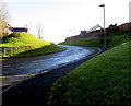
Cooksyeat View, Kilgetty
Cul-de-sac at the eastern edge of Kilgetty.
Image: © Jaggery
Taken: 19 Jan 2018
0.09 miles
4
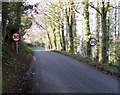
Start of the 30 zone on the eastern approach to Kilgetty
The National Speed Limit on the unnamed road from Windyhill drops to 30mph.
Image: © Jaggery
Taken: 19 Jan 2018
0.10 miles
5
End of the 30 zone beyond the eastern edge of Kilgetty
The speed limit on the unnamed road towards Windyhill increases to the National Speed Limit.
Image: © Jaggery
Taken: 19 Jan 2018
0.10 miles
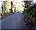
6
End of the 30 zone on Carmarthen Road east of Kilgetty
The 30mph speed limit increases to the National Speed Limit on the descent towards the A477.
Image: © Jaggery
Taken: 6 Jan 2018
0.12 miles
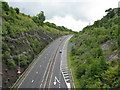
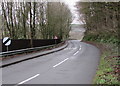
7
Ascent towards Kilgetty
Part of the long ascent of Carmarthen Road from the A477 towards the eastern edge of Kilgetty.
Image: © Jaggery
Taken: 6 Jan 2018
0.12 miles
8
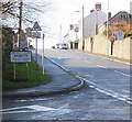
Welcome to Kilgetty - Please drive carefully
Alongside Carmarthen Road at the eastern edge of Kilgetty, a village in Pembrokeshire. The text is also in Welsh.
Image: © Jaggery
Taken: 19 Jan 2018
0.12 miles
9
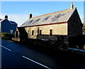
Bwthyn Sant Mair, Carmarthen Road, Kilgetty
Welsh for Saint Mary's Cottage, Bwthyn Sant Mair is the converted former St Mary's Mission Church.
Image: © Jaggery
Taken: 19 Jan 2018
0.12 miles
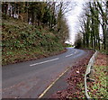
10
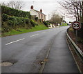
Start of the 30 zone on the eastern approach to Kilgetty
The National Speed Limit on Carmarthen Road drops to 30mph.
Image: © Jaggery
Taken: 6 Jan 2018
0.12 miles