IMAGES TAKEN NEAR TO
Park Gardens, KILGETTY, SA68 0AA
Introduction
This page details the photographs taken nearby to Park Gardens, SA68 0AA by members of the Geograph project.
The Geograph project started in 2005 with the aim of publishing, organising and preserving representative images for every square kilometre of Great Britain, Ireland and the Isle of Man.

There are currently over 7.5m images from over14,400 individuals and you can help contribute to the project by visiting https://www.geograph.org.uk
Image Map
Images are licensed for reuse under creativecommons.org/licenses/by-sa/2.0
Notes
- Clicking on the map will re-center to the selected point.
- The higher the marker number, the further away the image location is from the centre of the postcode.
Image Listing (54 Images Found)
Images are licensed for reuse under creativecommons.org/licenses/by-sa/2.0
Image
Details
Distance
1
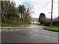
Down the A478 in Begelly, Pembrokeshire
Viewed from the corner of Parsonage Lane. Ahead for Kilgetty.
Image: © Jaggery
Taken: 19 Jan 2018
0.04 miles
3
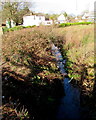
Unnamed stream in Begelly
Viewed from the north side of the A478 near Kilgetty.
Image: © Jaggery
Taken: 19 Jan 2018
0.07 miles
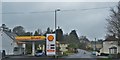
4

Shell filling station alongside the A478, Begelly
Image: © Jaggery
Taken: 19 Jan 2018
0.07 miles
5

Telecoms cabinet and bench near St Mary's Church lychgate, Begelly
Viewed in January 2018. The cabinet is not in a September 2011 Google Earth Street View.
Image: © Jaggery
Taken: 19 Jan 2018
0.09 miles
6
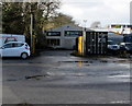
Travis Perkins, Begelly
Set back from the west side of the A478.
Image: © Jaggery
Taken: 19 Jan 2018
0.09 miles
7

Welcome to St Mary's Church Begelly
Alongside the lychgate entrance https://www.geograph.org.uk/photo/5662157 to the church.
Image: © Jaggery
Taken: 19 Jan 2018
0.09 miles
8
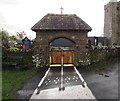
Lychgate entrance to St Mary's Church, Begelly, Pembrokeshire
From Parsonage Lane near the A478 junction. Derived from an old English word for a corpse, a lychgate is the roofed gateway to a churchyard, formerly used to shelter a coffin until the clergyman's arrival for the burial or pre-burial service. https://www.geograph.org.uk/photo/5662160 to the Welcome board on the left.
Image: © Jaggery
Taken: 19 Jan 2018
0.09 miles
9
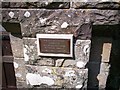
Plaque Begelly Church
Plaque for the resurfacing of paths - in memory of WILLIAM AND MARY DAVIES WHITEGRASS JUNE 1980.
Image: © welshbabe
Taken: 20 Aug 2013
0.09 miles
10
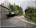
Bend in the A478, Begelly, Pembrokeshire
The A478 ascends past the Parsonage Lane junction.
Image: © Jaggery
Taken: 19 Jan 2018
0.10 miles