IMAGES TAKEN NEAR TO
Fifth Avenue, SWANSEA, SA6 7LX
Introduction
This page details the photographs taken nearby to Fifth Avenue, SA6 7LX by members of the Geograph project.
The Geograph project started in 2005 with the aim of publishing, organising and preserving representative images for every square kilometre of Great Britain, Ireland and the Isle of Man.

There are currently over 7.5m images from over14,400 individuals and you can help contribute to the project by visiting https://www.geograph.org.uk
Image Map
Images are licensed for reuse under creativecommons.org/licenses/by-sa/2.0
Notes
- Clicking on the map will re-center to the selected point.
- The higher the marker number, the further away the image location is from the centre of the postcode.
Image Listing (7 Images Found)
Images are licensed for reuse under creativecommons.org/licenses/by-sa/2.0
Image
Details
Distance
1
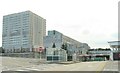
The DVLA at Morriston
Or the "DVLC" in old money. This photo cannot possibly convey how much this place looks like it was designed by Gerry Anderson for use in the original Thunderbirds series. It's from the time that architecture forgot.
Image: © Nigel Davies
Taken: 31 Jul 2005
0.18 miles
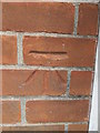
2
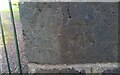
Ordnance Survey Cut Mark
This OS cut mark can be found on the gatepost of Pen Gwern. It marks a point 144.131m above mean sea level.
Image: © Adrian Dust
Taken: 11 May 2021
0.18 miles
5
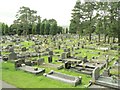
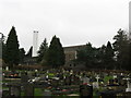
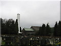
Morriston Cemetery
This is quite a large cemetery. The photo represents only about a quarter of the place. The cemetery is immediately adjacent to the DVLA. There's only 2 certainties in life: Death & Taxes - and they're both right here together in Morriston.
Image: © Nigel Davies
Taken: 31 Jul 2005
0.23 miles
6
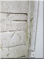
Ordnance Survey Cut Mark
This OS cut mark can be found on the north face of the Old Police Station building on Long View Road. Now housing. It marks a point 156.426m above mean sea level.
Image: © Adrian Dust
Taken: 16 Jul 2014
0.24 miles
7
Ordnance Survey Cut Mark
This OS cut mark can be found on the SW face of Clase Primary School. It marks a point 162.529m. above mean sea level.
Image: © Adrian Dust
Taken: 16 Jul 2014
0.25 miles