IMAGES TAKEN NEAR TO
Heol Cefni, SWANSEA, SA6 7ET
Introduction
This page details the photographs taken nearby to Heol Cefni, SA6 7ET by members of the Geograph project.
The Geograph project started in 2005 with the aim of publishing, organising and preserving representative images for every square kilometre of Great Britain, Ireland and the Isle of Man.

There are currently over 7.5m images from over14,400 individuals and you can help contribute to the project by visiting https://www.geograph.org.uk
Image Map (Loading...)


Getting Data...Please wait
Leaflet Map data © OpenStreetMap
Images are licensed for reuse under creativecommons.org/licenses/by-sa/2.0
Notes
- Clicking on the map will re-center to the selected point.
- The higher the marker number, the further away the image location is from the centre of the postcode.
Image Listing (14 Images Found)
Images are licensed for reuse under creativecommons.org/licenses/by-sa/2.0
Image
Details
Distance
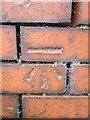
1
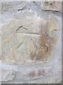
Ordnance Survey Cut Mark
This OS cut mark can be found on the roadside wall to the east of Trewyddfa Road. It marks a point 106.378m above mean sea level.
Image: © Adrian Dust
Taken: 16 Jul 2014
0.11 miles
2
Ordnance Survey Cut Mark
This OS cut mark can be found on the wall of No10 Caemawr Road. It marks a point 103.693m above mean sea level.
Image: © Adrian Dust
Taken: 16 Jul 2014
0.13 miles
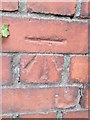
3
Carmel Chapel
There is an OS cut mark on the chapel wall. http://www.geograph.org.uk/photo/3838767
Image: © Adrian Dust
Taken: 6 Feb 2014
0.18 miles
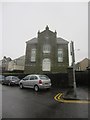
4
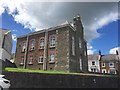
Converted chapel
Carmel chapel - now converted to residential use.
Image: © Alan Hughes
Taken: 10 Aug 2018
0.18 miles
5
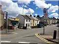
Street at Clun Ddu
Shop and housing at Clun Ddu, Morriston.
Image: © Alan Hughes
Taken: 10 Aug 2018
0.18 miles
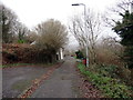
6
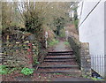
Llwybr Craig Trewyddfa / Craig Trewyddfa Path
Llwybr sy'n cysylltu Heol y Graig â Heol Trewyddfa.
A path linking Graig Road with Trewyddfa Road (trans. settlement of the prominent hill).
Image: © Alan Richards
Taken: 8 Jan 2020
0.18 miles
7
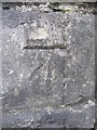
Ordnance Survey Cut Mark
This OS cut mark can be found on the wall of Carmel Chapel. It marks a point 77.252m above mean sea level. http://www.geograph.org.uk/photo/3838774
Image: © Adrian Dust
Taken: 6 Feb 2014
0.19 miles
8
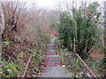
Llwybr Craig Trewyddfa / Craig Trewyddfa Path
Llwybr sy'n cysylltu Heol Trewyddfa â Heol y Graig.
A path linking Trewyddfa Road (trans. settlement of the prominent hill) with Graig Road.
Image: © Alan Richards
Taken: 8 Jan 2020
0.19 miles
9
Ordnance Survey Cut Mark
This OS cut mark can be found on the gatepost of No244 Mynydd Garnllwyd Road. It marks a point 126.870m above mean sea level.
Image: © Adrian Dust
Taken: 16 Jul 2014
0.20 miles
10
Heol yng Nghraig Trewyddfa / Road in Craig Trewyddfa
Heol y Graig yng Nghraig Trewyddfa.
Graig Road in Craig Trewyddfa (trans. settlement of the prominent hill)
Image: © Alan Richards
Taken: 8 Jan 2020
0.20 miles