IMAGES TAKEN NEAR TO
Martin Street, SWANSEA, SA6 7BJ
Introduction
This page details the photographs taken nearby to Martin Street, SA6 7BJ by members of the Geograph project.
The Geograph project started in 2005 with the aim of publishing, organising and preserving representative images for every square kilometre of Great Britain, Ireland and the Isle of Man.

There are currently over 7.5m images from over14,400 individuals and you can help contribute to the project by visiting https://www.geograph.org.uk
Image Map (Loading...)


Getting Data...Please wait
Leaflet Map data © OpenStreetMap
Images are licensed for reuse under creativecommons.org/licenses/by-sa/2.0
Notes
- Clicking on the map will re-center to the selected point.
- The higher the marker number, the further away the image location is from the centre of the postcode.
Image Listing (97 Images Found)
Images are licensed for reuse under creativecommons.org/licenses/by-sa/2.0
Image
Details
Distance
1
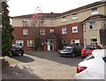
St Martin's Lodge, Morriston, Swansea
Set back from the west side of the B4603 Martin Street.
Image: © Jaggery
Taken: 12 Nov 2018
0.02 miles
2
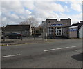
EuroBlinds, 30 Martin Street, Swansea
Viewed across the B4603 in the Morriston area of Swansea.
Image: © Jaggery
Taken: 12 Nov 2018
0.03 miles
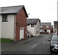
3
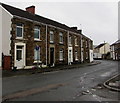
Row of stone houses, Market Street, Morriston, Swansea
On the east side of the street viewed from the corner of Banwell Street looking south.
The sign on the left shows that the road ahead is not a through route for motor vehicles.
Image: © Jaggery
Taken: 16 Oct 2018
0.04 miles
4
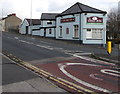
Swan Inn, Morriston, Swansea
The Martin Street side of the pub at 564 Neath Road. https://www.geograph.org.uk/photo/5973466 to a closer view of the name sign.
Image: © Jaggery
Taken: 12 Nov 2018
0.04 miles
5
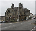
St James Veterinary Group, 66 Martin Street, Morriston, Swansea
Vets in the Grade II listed building on the corner of Banwell Street. Erected by Swansea Council in 1875, the building originally included a police station, reading room (later a library) and a house. Later used as a fire station.
Image: © Jaggery
Taken: 16 Oct 2018
0.05 miles
6
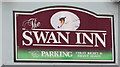
Swan Inn name sign, Morriston, Swansea
On the wall here. https://www.geograph.org.uk/photo/5973462
Image: © Jaggery
Taken: 12 Nov 2018
0.05 miles
7
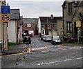
Start of the 20 zone, Banwell Street, Morriston, Swansea
The 30mph speed limit on the B4603 Martin Street drops to 20mph along Banwell Street.
The blue sign shows that this route is unsuitable for heavy goods vehicles. The text is also in Welsh.
Image: © Jaggery
Taken: 16 Oct 2018
0.06 miles
8
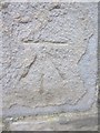
Ordnance Survey Cut Mark
This OS cut mark can be found on the west face of the St James Veterinary Group building on Martin Street. It marks a point 28.494m above mean sea level.
Image: © Adrian Dust
Taken: 28 Jan 2014
0.06 miles
9
North side of Banwell Street, Morriston, Swansea
This part of Banwell Street is between Martin Street and Market Street (ahead).
Image: © Jaggery
Taken: 16 Oct 2018
0.06 miles
10
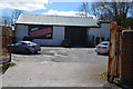
Brays Powerhouse Gym - Banwell Street
Former Great War Drill Hall.
Image: © John M
Taken: 4 Apr 2015
0.07 miles