IMAGES TAKEN NEAR TO
Kiln Park Road, NARBERTH, SA67 8UA
Introduction
This page details the photographs taken nearby to Kiln Park Road, SA67 8UA by members of the Geograph project.
The Geograph project started in 2005 with the aim of publishing, organising and preserving representative images for every square kilometre of Great Britain, Ireland and the Isle of Man.

There are currently over 7.5m images from over14,400 individuals and you can help contribute to the project by visiting https://www.geograph.org.uk
Image Map (Loading...)


Getting Data...Please wait
Leaflet Map data © OpenStreetMap
Images are licensed for reuse under creativecommons.org/licenses/by-sa/2.0
Notes
- Clicking on the map will re-center to the selected point.
- The higher the marker number, the further away the image location is from the centre of the postcode.
Image Listing (37 Images Found)
Images are licensed for reuse under creativecommons.org/licenses/by-sa/2.0
Image
Details
Distance
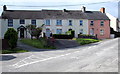
1
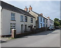
Station Approach houses, Narberth
Situated between Narberth railway station about 80 metres behind
the camera, and the Kiln Park Road junction out of shot ahead.
Image: © Jaggery
Taken: 31 Jul 2015
0.01 miles
3
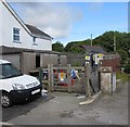
Station Approach electricity substation, Narberth
Viewed across Station Approach near the Kiln Park Road junction, about 90 metres from Station Road,
despite which the Western Power Distribution electricity substation identifier on the padlocked wooden gate is
STATION ROAD NARBERTH S/S 601648.
Image: © Jaggery
Taken: 31 Jul 2015
0.02 miles
5
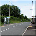
Kiln Park Road bus shelter, Narberth
Viewed from the corner of Station Approach. http://www.geograph.org.uk/photo/4593545
Image: © Jaggery
Taken: 31 Jul 2015
0.03 miles
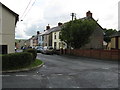
6
Station Approach, Narberth
Dead-end road to Narberth railway station http://www.geograph.org.uk/photo/4593011 viewed across Kiln Park Road.
Image: © Jaggery
Taken: 31 Jul 2015
0.04 miles
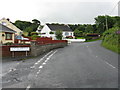
7
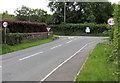
Southern end of Kiln Park Road, Narberth
The 30mph speed limit along residential Kiln Park Road increases to 40mph at the B4314 junction.
Image: © Jaggery
Taken: 31 Jul 2015
0.04 miles
8
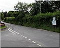
Directions signs facing Kiln Park Road, Narberth
The signs are alongside the B4314. Turn right for the centre of
Narberth, left for the crematorium, Princes Gate and Tavernspite.
Image: © Jaggery
Taken: 31 Jul 2015
0.05 miles
9
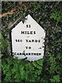
Old Milestone by the B4314, east of Narberth
Pembroke single plate by the B4314, in parish of Narberth (Pembrokeshire District), Narberth, just East of slip road to the A478.
New housing development at location and milestone no longer visible on Streetview. Possibly hidden behind new fence.
Inscription reads:-
21
MILES
760 YARDS
TO
CARMARTHEN
Grade II listed by Cadw.
Reference Number: 6536 https://cadwpublic-api.azurewebsites.net/reports/listedbuilding/FullReport?lang=&id=6536
Surveyed
Milestone Society National ID: PEM_CMNB21
Image: © Milestone Society
Taken: Unknown
0.05 miles
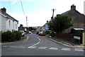
10
Railway Terrace, Narberth
Row of four houses viewed across Station Approach near Narberth railway station. http://www.geograph.org.uk/photo/4593011
Image: © Jaggery
Taken: 31 Jul 2015
0.06 miles